
Premier extends high grade mineralization at McCoy-Cove
Premier extends high grade mineralization at McCoy-Cove
Canada NewsWire
THUNDER BAY, ON, Nov. 10, 2016
 (CNW Group/Premier Gold Mines Limited)")
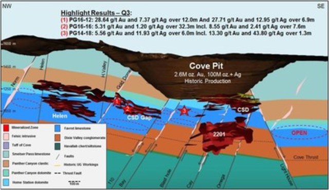
Drill intercepts include 28.64 g/t Au and 7.37 g/t Ag across 12.0 m
Shares Issued: 201,313,187
THUNDER BAY, ON, Nov. 10, 2016 /CNW/ - PREMIER GOLD MINES LIMITED (TSX:PG) ("Premier", "the Company") is pleased to announce additional positive drill results that indicate further extension of the high grade CSD Gap zone at the Company's 100%-owned McCoy-Cove Gold Project, situated along the Battle Mountain-Eureka Trend in Nevada. The results from the ongoing 15,000 metre drill program listed in this release all occur between the Helen Zone and the historic Cove South Deep (CSD) underground zone, and continue to exhibit high-grade mineralization over substantial widths.
The focus of the ongoing drill program is to delineate and expand the zone of the Carlin-style gold and silver system within the CSD Gap, as shown in Figure 1 and Table 1 below. Results from drill-hole PG16-12, a 100m step-out along strike from hole PG16-10 extends high grade mineralization towards the Helen Zone and remains open for expansion along strike to the northwest. Upon completion of the program Premier plans to commence a property-wide mineral resource estimate and a Preliminary Economic Assessment.
Highlights of the recent results include:
- PG16-12: 28.64 g/t Au and 7.37 g/t Ag over 12.0m at 599.7m (or 0.84 oz/t Au and 0.21 oz/t Ag over 39.5 ft.) and 27.71 g/t Au and 12.95 g/t Ag over 6.9m at 627.1m (or 0.81 oz/t Au and 0.38 oz/t Ag over 22.5 ft.)
- PG16-14: 6.16 g/t Au and 0.86 g/t Ag over 10.8m at 653.9m (or 0.18 oz/t Au and 0.03 oz/t Ag over 35.5 ft.) including 9.48 g/t Au and 0.45 g/t Ag over 3.2m (or 0.0.28 oz/t Au and 0.01 oz/t Ag over 10.5 ft.)
- PG16-16: 5.31 g/t Au and 1.20 g/t Ag over 32.3m at 551.7m (or 0.15 oz/t Au and 0.04 oz/t Ag over 106 ft.) including 8.55 g/t Au and 2.41 g/t Ag over 7.6m ( or 0.25 oz/t Au and 0.07 oz/t Ag over 25.0 ft.)
- PG14-18: 5.56 g/t Au and 11.93 g/t Ag over 6.0m (or 0.16 oz/t Au and 0.35 oz/t Ag over 19.8 ft.) at 571.1m. This hole was drilled to complete the core tail of a pre-collared hole drilled in 2014
"The 2016 exploration program continues to exceed expectations with PG16-16 further closing the gap with the Helen Zone to the northwest" stated Chad Peters, Nevada Exploration Manager for Premier on the Company's C-Suite Blog (http://www.premiergoldmines.com/news/c-suite-blog). "We currently have four rigs mobilized at McCoy-Cove with the remainder of 2016 focusing on select Helen and CSD Gap infill and expansion drilling to support the upcoming Q1 2017 resource estimate."
The Cove geologic model proposes that the most robust gold and silver mineralization in the Helen deposit, the CSD gap and the 2201 Zones are closely associated with the deep-seated Cove thrust fault and altered mafic sills that acted as both primary structural controls and fluid conduits. The 2016 drill results continue to confirm this model as well as highlight multiple, high-grade silver intercepts outside of the defined CSD Gap horizon. These intercepts are directly adjacent to the Cove thrust and the historically untested CT-1 splay which suggests additional potential remains to define high grade gold and silver mineralization outside of the known mineralized horizon. The ongoing drill program will therefore also target mineralization hosted within the hanging wall of the CT-1 splay as a means to further expand the known footprint of the CSD Gap and Helen deposits.
Table 1: Select Q3 2016, CSD Gap exploration drill program results
|
Hole ID |
Coordinates(1) |
Azimuth |
From |
To |
Core |
Au |
Ag |
Core |
Au |
Ag |
Comment |
|
PG16-12 |
4465432N/481977E |
047/-57 |
599.7 |
611.7 |
12.0 |
28.64 |
7.37 |
39.5 |
0.84 |
0.21 |
CSD Gap |
|
601.1 |
605.2 |
4.1 |
50.96 |
11.84 |
13.5 |
1.49 |
0.35 |
including | |||
|
627.1 |
634.0 |
6.9 |
27.71 |
12.95 |
22.5 |
0.81 |
0.38 |
CSD Gap | |||
|
644.7 |
653.8 |
9.1 |
7.17 |
12.80 |
30.0 |
0.21 |
0.37 |
CSD Gap | |||
|
648.6 |
651.7 |
3.0 |
15.22 |
12.95 |
10.0 |
0.44 |
0.38 |
including | |||
|
PG16-13 |
4465389N/481988E |
059/-49 |
Abandoned | ||||||||
|
PG16-14 |
4465389N/481988E |
071/-51 |
532.5 |
534.3 |
1.8 |
5.26 |
1.25 |
6.0 |
0.15 |
0.04 |
CSD Gap |
|
653.9 |
664.8 |
10.8 |
6.16 |
0.86 |
35.5 |
0.18 |
0.03 |
CSD Gap | |||
|
653.9 |
655.5 |
1.6 |
9.43 |
1.97 |
5.2 |
0.28 |
0.06 |
including | |||
|
657.5 |
660.7 |
3.2 |
9.48 |
0.45 |
10.5 |
0.28 |
0.01 |
and | |||
|
746.9 |
748.3 |
1.4 |
7.97 |
10.80 |
4.5 |
0.23 |
0.32 |
CSD Gap | |||
|
PG16-15A |
4465563N/481906E |
059/-60 |
465.6 |
467.7 |
2.1 |
3.17 |
99.00 |
7.0 |
0.09 |
2.89 |
Upper |
|
PG16-16 |
4465563N/481906E |
047/-55 |
551.7 |
584.0 |
32.3 |
5.31 |
1.20 |
106.0 |
0.15 |
0.04 |
CSD Gap |
|
559.9 |
567.5 |
7.6 |
8.55 |
2.41 |
25.0 |
0.25 |
0.07 |
including | |||
|
580.6 |
584.0 |
3.4 |
12.04 |
1.88 |
11.0 |
0.35 |
0.05 |
and | |||
|
653.0 |
661.7 |
8.7 |
7.44 |
3.29 |
28.5 |
0.22 |
0.10 |
CSD Gap | |||
|
732.7 |
735.2 |
2.4 |
8.61 |
3.17 |
8.0 |
0.25 |
0.09 |
CSD Gap | |||
|
PG16-17 |
4465432N/481977E |
069/-66 |
429.3 |
431.6 |
2.3 |
9.26 |
3.63 |
9.3 |
0.27 |
0.11 |
CSD Gap |
|
584.6 |
585.6 |
1.0 |
5.70 |
3.20 |
5.7 |
0.17 |
0.09 |
CSD Gap | |||
|
PG14-18 |
4464981N/482364E |
025/-44 |
563.1 |
564.9 |
1.8 |
8.17 |
3.76 |
6.0 |
0.24 |
0.11 |
CSD Gap |
|
571.1 |
577.1 |
6.0 |
5.56 |
11.93 |
19.8 |
0.16 |
0.35 |
CSD Gap | |||
|
571.1 |
572.4 |
1.3 |
13.30 |
43.80 |
4.3 |
0.39 |
1.28 |
including | |||
|
585.4 |
587.2 |
1.8 |
5.36 |
289.93 |
6.0 |
0.16 |
8.46 |
CSD Gap | |||
|
1) UTM NAD83, Zone 11 2) True widths are estimated to be 80 to 90% of core length | |||||||||||
All abbreviations used in this press release are available by following this link (click here) or by visiting the gold 101 & mining 101 page on the Company's website. Supplementary images complementing this press release can be viewed on the press release section on the company's website.
Plan of Operations/2017 Guidance
The Cove-Helen Underground Exploration Plan of Operations (PoO) was approved in 2013 granting Premier the option of pursuing an underground exploratory drill program as well as test mining in the Helen Zone. A supplementary 2016 budget has led Premier to initiate preliminary engineering, dewatering and baseline studies required to advance the underground exploration PoO towards development. Dewatering was an important aspect of historic mine operations at Cove and as a result, the installation of vibrating wire piezometers in select exploration drill holes commenced in Q2 in order to monitor groundwater in the vicinity of the Helen and CSD Gap deposits. Preliminary dewatering simulations of the proposed test mining scenario are now complete and results indicate that the potential dewatering outflow levels for the test mining scenario would fall within the currently permitted PoO. Further optimization and validation of the dewatering scenario is ongoing including a pump test that is planned for Q1 2017 to confirm dewatering rates prior to initiating a PEA in H2 2017.
About McCoy-Cove
The McCoy-Cove Property is located along the prolific Battle Mountain-Eureka Trend that is host to numerous multi-million ounce producing and past-producing mines. The Property includes the historic McCoy and Cove open pits and underground operations, which produced a combined 3.3 million ounces of gold and 110 million ounces of silver between 1986 and 2003. The property is located in close proximity to excellent infrastructure (including paved roads & power) and all permits are in place for an advanced surface drilling campaign.
Stephen McGibbon, P. Geo., is the Qualified Person for the information contained in this press release and is a Qualified Person within the meaning of National Instrument 43-101. Drill samples were sent to ALS Laboratories in Reno, Nevada for analysis with the analytical facility utilizing 30 gram fire assay with an AA finish for RC samples and 30 gram fire assay with AA finish and ICP-MS 30 element scan from 4-acid digestion for core samples. Over-limit samples receive an automatic gravimetric finish.
Premier Gold Mines Limited is a gold producer and respected exploration and development company with a high-quality pipeline of precious metal projects in proven, accessible and safe mining jurisdictions in Canada, the United States, and Mexico.
This Press Release contains certain information that may constitute "forward-looking information" under applicable Canadian securities legislation. Forward-looking information includes, but is not limited to, statements about strategic plans, including future operations, future work programs, capital expenditures, discovery and production of minerals, price of gold and currency exchange rates, timing of geological reports and corporate and technical objectives. Forward-looking information is necessarily based upon a number of assumptions that, while considered reasonable, are subject to known and unknown risks, uncertainties, and other factors which may cause the actual results and future events to differ materially from those expressed or implied by such forward-looking information, including the risks inherent to the mining industry, adverse economic and market developments and the risks identified in Premier's annual information form under the heading "Risk Factors". There can be no assurance that such information will prove to be accurate, as actual results and future events could differ materially from those anticipated in such information. Accordingly, readers should not place undue reliance on forward-looking information. All forward-looking information contained in this press release is given as of the date hereof and is based upon the opinions and estimates of management and information available to management as at the date hereof. Premier disclaims any intention or obligation to update or revise any forward-looking information, whether as a result of new information, future events or otherwise, except as required by law.
SOURCE Premier Gold Mines Limited
Image with caption: "Figure 1: Cove Deposits Schematic Longitudinal Section (looking north-east) (CNW Group/Premier Gold Mines Limited)". Image available at: http://photos.newswire.ca/images/download/20161110_C8354_PHOTO_EN_815058.jpg

Please make the indicated changes including the new text: US quotes snapshot data provided by IEX. Additional price data and company information powered by Twelve Data.