
Grid Metals Donner Lake Lithium Property Drill Results and Project Development Update
PEA Underway at Makwa Mayville Ni-Cu-PGM-Co Property
TORONTO, ON / ACCESSWIRE / July 28, 2022 / Grid Metals Corp. (the "Company") (TSXV:GRDM)(OTCQB:MSMGF) is pleased to report the results from the final three holes completed in the Phase 1 drill program at its Donner Lake lithium property (the "Property") in southeastern Manitoba. In addition, the Company has initiated certain project development activities including baseline environmental work and metallurgical testwork on both the Northwest and Main dykes. The property is located in the Winnipeg River pegmatite field, which hosts the world-class Tanco pegmatite and the associated Tanco lithium-cesium-tantalum mine and concentrator. The property is a 75%/25% joint venture between Grid Metals Corp and Lithium Royalty Corp., a leading player in global lithium finance.
Drilling Highlights:
- Results from the final three holes for the February-April 2022 Northwest Dyke drilling program include the following length-weighted average grades:
- 7.3 metres averaging 1.17% Li2O in GDL22-16 (from 239.9 metres) including 2.1 metres averaging 1.92% Li2O
- 5.5 metres averaging 1.49% Li2O in GDL22-17 (from 279.8 metres) including 3.0 metres averaging 2.41% Li2O
- 4.7 metres averaging 1.00% Li2O in GDL22-18 (from 227.0 metres) including 1.67 metres averaging 1.57% Li2O
Holes 16-18 were drilled to intersect the Northwest Dyke below previously reported drill holes, between 150 and 250 metres vertical depth. Note that the Northwest Dyke intersection lengths reported above do not represent the true thickness of the dyke, which is estimated to typically range from 4 to 8 metres, representing 50-70% of the reported intersection lengths. Complete analytical results for holes GDL22-16, -17 and -18, together with drill hole specifications for these and previously reported holes, are provided in the Appendices accompanying this release. Relative drill hole pierce points into the Northwest Dyke are shown on the accompanying longitudinal section.
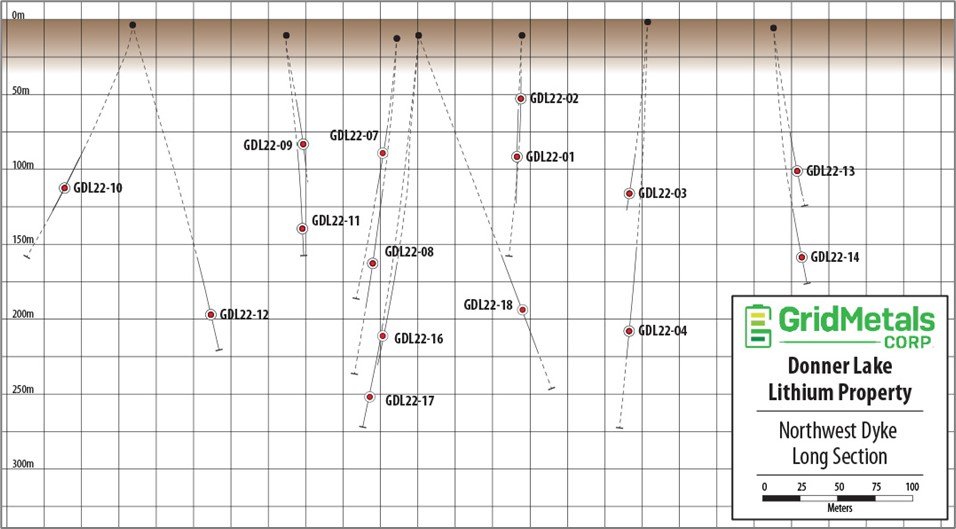
Above: Longitudinal section, looking west, showing relative 3D position of the February-April 2022 drill hole pierce points into the Northwest Dyke, Donner Lake Lithium Property. Holes GDL22-16 to 18, reported here, are amongst the deepest intersections of the Northwest Dyke to date.
Analysis: Phase 1 Drilling Results
The Northwest Dyke has now been traced by drilling for ~600 metres along strike and to a vertical depth of ~250 metres. Grid's 2022 drilling was the first drilling completed at the Northwest Dyke since 1955. The holes were drilled at an average of 100 to150 metre stepouts and demonstrated lateral and vertical continuity. As well the Northwest Dyke remains open to depth and along strike. A total of 15 holes successfully intersected the Northwest Dyke over a strike length of ~600 metres and vertical depths of 50 to 250 metres below surface. Visual logging supported by whole-rock analytical data indicate that the Northwest Dyke is a zoned, LCT-type pegmatite dyke having a near-vertical orientation and showing very consistent Li2O, Ta2O5, Cs2O and Rb2O grades.
Mr. Carey Galeschuk, Grid's Vice President, Lithium Exploration, stated, "The Phase 1 drilling program targeting the Northwest Dyke was very successful. The dyke shows good continuity, consistent mineralogical and grade variability, and a persistent spodumene-rich zone. Together with the Main Dyke we now have two clear targets for our initial near surface resource delineation drilling. As well, critical new exploration data is being acquired during the ongoing field campaign will provide the first property-scale information of the overall potential of the Donner Lake pegmatite field as numerous historically mapped pegmatites are presently being characterized to fully understand their lithium-bearing potential."
The Northwest Dyke is the second drill-defined LCT type pegmatite with significant strike length on the Donner Lake property. Similar lithium grades were previously reported in the Company's 2018 drill holes targeting the Main Dyke over a strike length of ~ 775 metres. The Main Dyke is located ~1.5 km to the east of the Northwest Dyke.
Future drill plans at the Main and Northwest Dykes will involve completing drilling over the known strike length of the two dykes to an approximate vertical depth of 300 metres to enable calculation of a 43-101 compliant mineral resource. It is expected that future resource drilling will be completed in conjunction with drilling of new exploration targets that are being generated from the current field program. Timing of the drill schedule will be released at a later date.
Anomalous Lithium Intersected in the West Dykes
Two additional reconnaissance exploration holes (GDL22-05 and -06) were drilled on the West Dykes - a cluster of mapped pegmatites with very limited historical data. The West Dykes are located 500 metres to the southwest of the Northwest Dyke (see plan map, below). Both holes intersected multiple, narrow felsic dykes with one or more intervals of lithium-rich pegmatite including:
- 3.6 metres of 0.7% Li2O from 225.0 metres, including a maximum individual sample grade of 0.65 metres of 3.0% Li2O in hole GDL22-05
- 1.8 metres averaging >2.0% Li2O (over limit values reported) from 187.3 metres in hole GDL22-06
Ratios of Li-Ta-Cs-Rb are similar to those reported for the Northwest Dyke drill holes. The West Dykes are part of a mapped pegmatite system that has a strike length of ~ 800 meters and is being mapped in detail and sampled as part of an ongoing field program.
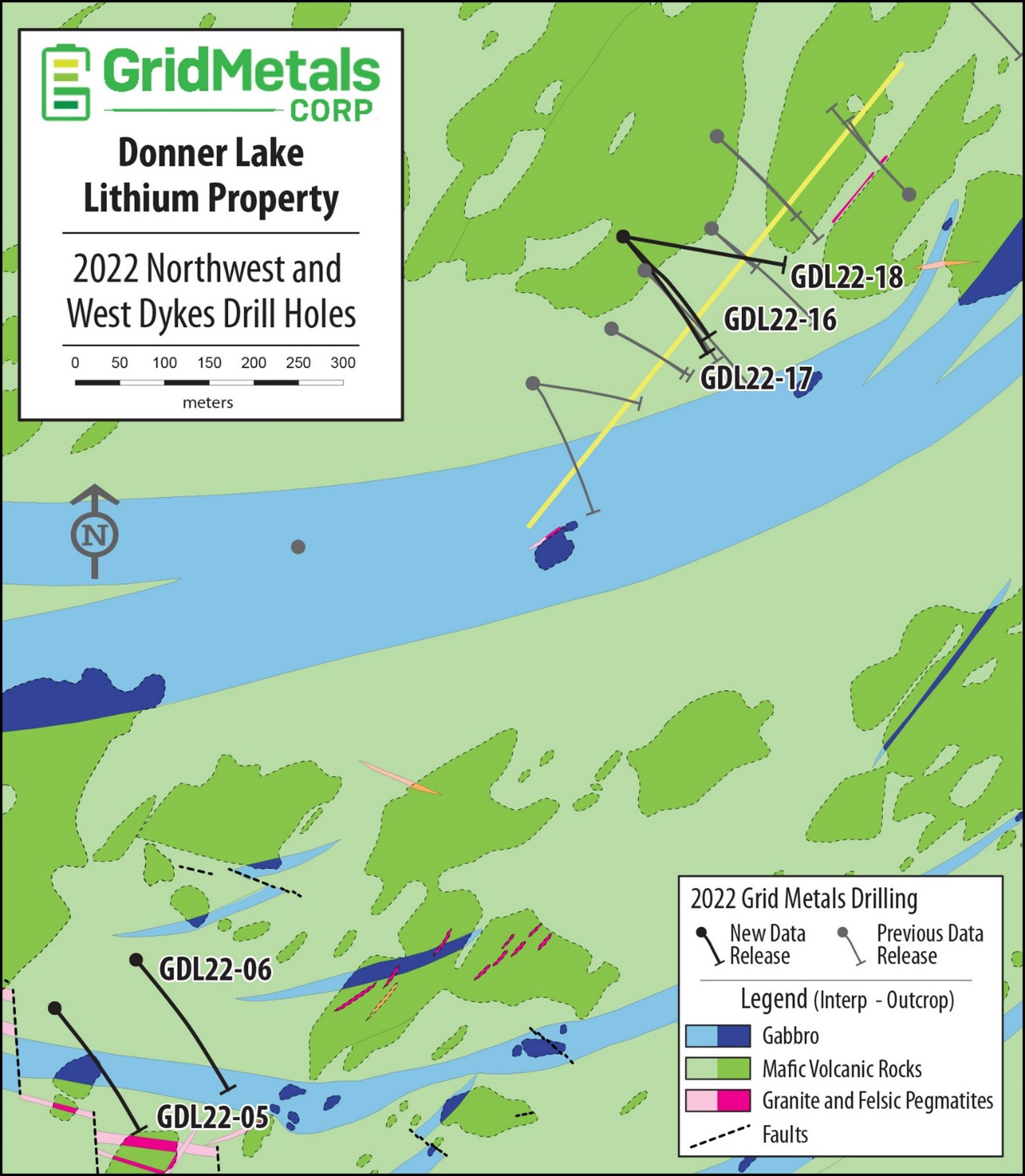
Above: Plan view map showing collars and traces of all 2022 exploration drill holes targeting the Northwest Dyke (GDL22-01 to -04 and GDL22-07 to 18) and West Dykes (GDL22-05 and -06), Donner Lake Lithium Property. Labelled holes are those discussed in this release.
Update on Other Project Activities
New outcrop samples from the previously unsampled WE, Northeast, Cat Creek and North Creek Pegmatites, which are located in the eastern and northern portion of the Mayville Property, have been sent to Actlabs (Thunder Bay) for analysis. Initial results are expected within the next several weeks. As well, surface samples from the pegmatite characterization program targeting the Main Dyke and West Dykes have also been sent to the lab. The field program remains ongoing and is focused on sampling and mapping of pegmatite dykes on the property and developing a lithogeochemical anomaly map. Lithogeochemistry is an exploration technique whereby host rocks (rocks that can host pegmatites that may or may not be visible on surface) are sampled on a grid pattern to detect geochemical changes including enrichment in lithium that are generated by the injection of pegmatites into the overall geology of the area. It has been proven in many locations to be a powerful exploration tool in finding unexposed pegmatites.
Above: Pegmatites in the Donner Lake area.
Project Development
The Company has sent representative drill core and coarse rejects from the 2022 Northwest Dyke drilling program and the 2018 Main Dyke drilling program to XPS Expert Process Solutions ("XPS") (a Glencore Company) in Falconbridge, Ontario. XPS will complete a preliminary series of Dense Media Separation and flotation-recovery tests along with quantitative mineralogical analysis of the composite samples prepared from these pegmatite materials. This metallurgical testwork will provide an initial characterization of the potential to produce a marketable spodumene concentrate from these two dykes.
Grid has retained Aecom Canada Ltd. ("Aecom") to complete baseline environmental work on the Donner Lake and Makwa Mayville project areas. Aecom has also been retained to prepare an Advanced Exploration Permit for the Donner Lake Property that would enable a bulk sample(s) to be extracted.
Grid has commissioned Micon International to complete an updated Preliminary Economic Assessment on the Makwa Mayville Ni-Cu-PGM-Co project.
Quality Assurance and Quality Control
Grid Metals applies best practice quality assurance and quality control ("QAQC") protocols on all of its exploration programs. For the Donner Lake drilling program, core was logged and sampled at the Company's core facility located on the Makwa Property. Generally, 1.0 metre sample lengths were used. Samples were bagged and tagged and then transported by secure carrier to the Actlabs (Thunder Bay) laboratory for sample preparation and analysis for lithium, cesium, tantalum and selected major and trace element abundances using a sodium peroxide fusion total digestion method followed by ICP-OES and ICP-MS analysis. The Company is using two lithium + rare metal certified reference materials ("CRMs") and two analytical blanks for the Donner Lake program to monitor analytical accuracy and check for cross contamination between samples.
Dave Peck, P.Geo., has reviewed the contents of this press release and is the qualified person for purposes of National Instrument 43-101.
About the Donner Lake Lithium Property
- The Property is owned 75% by Grid Metals Corp. and 25% by Lithium Royalty Corp. (LRC), which is funding 25% of the current exploration program. LRC holds an overriding 2% royalty on the property.
- The Property was acquired by Grid from Tantalum Mining Corporation of Canada Limited (Tanco) which has the first right to acquire products produced from the property at commercial terms and holds a 2% royalty on certain claims.
- Sinomine Canada is currently operating a lithium spodumene circuit at its Tanco Mine facility, located approximately 35 km to the southwest of the Donner Lake Property.
- Donner Lake is ~180 km from the provincial capital of Winnipeg and accessible by all season roads and logging trails and there is nearby access to Canada's major east-west railway line.
- Grid Metals has an exploration agreement in place with the Sagkeeng First Nation, whose Traditional Lands include the Donner Lake and Mayville properties.
- The Property has nearby access low-cost renewable power from Manitoba's extensive hydro-electric grid.
- There are multiple LCT-type pegmatite dykes on the Property including the Main Dyke that, in 2018, was drill tested by Grid over a ~ 800 m strike length. The dykes are located along a ~9 km long prospective geological contact between the Bird River greenstone belt and the Makwa Lake batholith and occupy obvious structural trends.
- The Main Dyke and Northwest Dyke together supported a non-compliant historical resource estimate of 3.8 million tons at a grade of 1.28% Li2O (Manitoba Mines Branch Assessment file 91769A). This resource estimate cannot be independently verified by the Company. The Company is preparing to resume drilling to establish a maiden NI 43-101 lithium resource while continuing exploration for other LCT-type pegmatites on the Property.
- The Property is significantly underexplored with a large portion of the prospective geology having seen no prior lithium exploration.
- The Property is also located on the same geographical footprint as the Company's Mayville M2 Cu-Ni-PGE deposit, which is the larger of two pit-constrained mineral resources that were the subject of the April 2014 Preliminary Economic Assessment report authored by RPA Associates. The company recently commissioned a new Preliminary Economic Assessment study being headed up by Micon International.
Amendments To Equity Incentive Plan
The Board of Directors have approved certain amendments to the Equity Incentive Plan of the Company, which were requested by the TSX Venture Exchange (the "Exchange") in order to comply with the Exchange's policies with respect to security based compensation plans. The principal changes are as follows:
- Deleting the ability to exclude options issued on a takeover or amalgamation in the number authorized under the plan;
- Removing the power of the Administrator to approve transfers or assignments of incentive awards;
- Removing the power of the Administrator to accelerate options to persons providing investor relations services;
- The grant of dividend equivalents will reduce the available pool of shares reserved for RSUs and DSUs, and will be included in 10%/5%/2% grant limits;
- Except for the investor relations service providers, any acceleration of vesting must be approved by the Exchange first; and,
- An amendment to any general vesting provisions of an Award will require Exchange approval.
These amendments only affect the Incentive Plan of the Company approved at the last annual meeting of shareholders. The Board of Directors intends to present a new incentive plan which will comply with the new Exchange policy in respect of security based compensation to shareholders at the next annual meeting.
About Grid Metals Corp.
Grid Metals Corp. maintains an attractive portfolio of exploration and development stage properties focused on battery metals (nickel, lithium, copper, cobalt, platinum group metals cobalt) and emission reduction technologies (palladium, platinum, rhodium) in the Provinces of Manitoba and Ontario, Canada. The Company is currently focused on advancing both its Donner Lake lithium and its PEA stage Makwa-Mayville Cu-Ni-PGM-Co assets in southeastern Manitoba.
To find out more about Grid Metals Corp., please visit www.gridmetalscorp.com.
On Behalf of the Board of Grid Metals Corp.
Robin Dunbar - President, CEO & Director
Telephone: 647 201 6844 Email: [email protected]
David Black - Investor Relations Email: [email protected] 416 955-4773
Appendix 1: Analytical Results, Drill Hole GDL22-16, Northwest Pegmatite Dyke, Donner Lake Lithium Property, Southeastern Manitoba.
| Sample# | From (m) | To (m) | Length (m) | Li2O (%) | Ta2O5 (ppm) | Cs2O (ppm) | Rb2O (%) |
AM752896 | 239.4 | 239.9 | 0.5 | 0.14 | 76.7 | 200 | 0.36 |
AM752898 | 239.9 | 241.0 | 1.1 | 1.48 | 135 | 248 | 0.38 |
AM752899 | 241.0 | 242.1 | 1.1 | 1.87 | 97.9 | 179 | 0.30 |
AM752901 | 242.1 | 243.1 | 0.9 | 0.24 | 92.8 | 149 | 0.30 |
AM752902 | 243.1 | 244.1 | 1.0 | 0.23 | 76.5 | 151 | 0.33 |
AM752904 | 244.1 | 245.1 | 1.1 | 0.36 | 63.8 | 164 | 0.32 |
AM752905 | 245.1 | 246.1 | 1.0 | 2.58 | 50.2 | 80.6 | 0.13 |
AM752907 | 246.1 | 247.2 | 1.1 | 1.37 | 67.4 | 199 | 0.43 |
AM752908 | 247.2 | 248.2 | 1.0 | 0.25 | 77.0 | 149 | 0.32 |
AM752909 | 248.2 | 249.2 | 1.0 | 0.19 | 69.5 | 133 | 0.36 |
AM752911 | 249.2 | 250.2 | 1.0 | 0.11 | 71.7 | 88.0 | 0.25 |
Interval Averages | |||||||
NW Dyke | 239.9 | 247.2 | 7.3 | 1.17 | 84.0 | 170 | 0.32 |
inc. | 239.9 | 242.1 | 2.2 | 1.67 | 116 | 214 | 0.34 |
with | 245.1 | 247.2 | 2.1 | 1.92 | 59.5 | 145 | 0.29 |
Appendix 2: Analytical Results, Drill Hole GDL22-17, Northwest Pegmatite Dyke, Donner Lake Lithium Property, Southeastern Manitoba.
| Sample# | From (m) | To (m) | Length (m) | Li2O (%) | Ta2O5 (ppm) | Cs2O (ppm) | Rb2O (%) |
AM752934 | 279.2 | 279.8 | 0.7 | 0.18 | 67.5 | 126 | 0.28 |
AM752936 | 279.8 | 280.1 | 0.3 | 0.30 | 110 | 142 | 0.23 |
AM752937 | 280.1 | 281.1 | 1.0 | 1.78 | 64.8 | 103 | 0.17 |
AM752939 | 281.1 | 282.1 | 1.0 | 2.84 | 61.8 | 120 | 0.17 |
AM752941 | 282.1 | 283.1 | 1.0 | 2.61 | 44.2 | 104 | 0.15 |
AM752942 | 283.1 | 283.7 | 0.6 | 0.66 | 37.3 | 172 | 0.38 |
AM752943 | 283.7 | 284.5 | 0.8 | 0.33 | 72.6 | 235 | 0.38 |
AM752944 | 284.5 | 285.3 | 0.8 | 0.28 | 65.6 | 254 | 0.46 |
AM752946 | 285.3 | 286.3 | 1.0 | 0.13 | 42.9 | 146 | 0.30 |
AM752947 | 286.3 | 287.3 | 1.0 | 0.13 | 56.9 | 177 | 0.38 |
AM752948 | 287.3 | 288.2 | 0.9 | 0.14 | 81.9 | 142 | 0.26 |
Interval Averages | |||||||
NW Dyke | 279.8 | 287.3 | 7.5 | 1.13 | 58.3 | 159 | 0.28 |
inc. | 279.8 | 285.3 | 5.5 | 1.49 | 61.3 | 158 | 0.26 |
with | 280.1 | 283.1 | 3.0 | 2.41 | 56.9 | 109 | 0.16 |
Appendix 3: Analytical Results, Drill Hole GDL22-18, Northwest Pegmatite Dyke, Donner Lake Lithium Property, Southeastern Manitoba.
| Sample# | From (m) | To (m) | Length (m) | Li2O (%) | Ta205 (ppm) | Cs20 (ppm) | Rb2O (%) |
AM752627 | 226.21 | 226.36 | 0.15 | 0.17 | 119 | 166 | 0.24 |
AM752628 | 226.36 | 227.00 | 0.64 | 0.84 | 148 | 218 | 0.30 |
AM752629 | 227.00 | 228.00 | 1.00 | 1.61 | 120 | 224 | 0.30 |
AM752631 | 228.00 | 228.67 | 0.67 | 1.52 | 89 | 154 | 0.27 |
AM752632 | 228.67 | 229.00 | 0.33 | 0.23 | 88 | 166 | 0.34 |
AM752633 | 229.00 | 230.00 | 1.00 | 0.16 | 97 | 140 | 0.29 |
AM752635 | 230.00 | 230.67 | 0.67 | 0.28 | 134 | 187 | 0.32 |
AM752636 | 230.67 | 231.67 | 1.00 | 1.61 | 79 | 149 | 0.28 |
AM752638 | 231.67 | 231.98 | 0.31 | 0.32 | 59 | 166 | 0.33 |
AM752639 | 231.98 | 232.18 | 0.20 | 0.27 | 102 | 209 | 0.36 |
AM752641 | 232.18 | 233.00 | 0.82 | 0.16 | 60 | 137 | 0.31 |
AM752642 | 233.00 | 234.03 | 1.03 | 0.15 | 88 | 140 | 0.36 |
AM752643 | 234.03 | 234.23 | 0.20 | 0.07 | 117 | 169 | 0.08 |
Interval Averages | |||||||
NW Dyke | 227.0 | 231.7 | 4.7 | 1.00 | 102 | 170 | 0.29 |
inc. | 226.4 | 228.7 | 2.3 | 1.37 | 119 | 202 | 0.29 |
and inc. | 227.0 | 228.7 | 1.7 | 1.57 | 108 | 196 | 0.29 |
Appendix 4: Analytical Results, Drill Holes GDL22-05 and GDL22-6, West Dykes, Donner Lake Lithium Property, Southeastern Manitoba.
| Sample# | From (m) | To (m) | Length (m) | Li2O (%) | Ta205 (ppm) | Cs20 (ppm) | Rb2O (%) |
| GDL22-05 | |||||||
AM752587 | 198.5 | 199.0 | 0.55 | 0.04 | 166 | 102 | 0.26 |
AM752588 | 199.0 | 199.8 | 0.83 | 0.02 | 100 | 46.6 | 0.13 |
AM752589 | 199.8 | 200.1 | 0.25 | 0.16 | 1.59 | 260 | 0.16 |
AM752606 | 225.0 | 226.1 | 1.13 | 0.16 | 0.68 | 11.7 | 0.01 |
AM752607 | 226.1 | 226.6 | 0.47 | 0.12 | 2.38 | 27.6 | 0.03 |
AM752608 | 226.6 | 227.4 | 0.82 | 0.28 | 62.1 | 75.3 | 0.22 |
AM752609 | 227.4 | 228.1 | 0.65 | 3.01 | 43.8 | 45.6 | 0.12 |
AM752611 | 228.1 | 228.6 | 0.53 | 0.04 | 55.6 | 68.9 | 0.23 |
| GDL22-06 | |||||||
AM752787 | 136.4 | 137.0 | 0.64 | 1.156 | 172 | 89.1 | 0.13 |
AM752789 | 137.0 | 137.5 | 0.46 | 0.228 | 122 | 123 | 0.23 |
AM752819 | 187.1 | 187.3 | 0.24 | 0.31 | 202 | 207 | 0.46 |
AM752821 | 187.3 | 188.2 | 0.91 | >2.0% | 53.6 | 84.8 | 0.15 |
AM752823 | 188.2 | 189.1 | 0.89 | >2.0% | 86.6 | 92.2 | 0.13 |
AM752824 | 189.1 | 189.3 | 0.21 | 0.106 | 174 | 133 | 0.19 |
AM752831 | 196.1 | 196.6 | 0.52 | 0.026 | 101 | 91.2 | 0.25 |
Interval Averages | |||||||
| GDL22-05 | 225.0 | 228.6 | 3.6 | 0.68 | 30.8 | 42.8 | 0.11 |
227.4 | 228.1 | 0.7 | 3.01 | 43.8 | 45.6 | 0.12 | |
| GDL22-06 | 136.4 | 137.5 | 1.1 | 0.77 | 151 | 103 | 0.17 |
187.3 | 189.1 | 1.8 | >2.0 | 69.9 | 88.5 | 0.14 |
Appendix 5: Specifications for all completed drill holes that intersected the Northwest Dyke, Donner Lake Lithium Property, Southeastern Manitoba. Easting and Northing coordinates are based on a NAD83 UTM Zone 15 projection. Depth values represent end of hole depths. Length values are core intervals for the main Northwest Dyke pegmatite intercepts. From values are the upper contact downhole depth of the Northwest Dyke. The true thickness of the dyke is estimated to range from 40 to 70% of the reported core lengths.
| Hole ID | Easting (m) | Northing (m) | Elevation (m) | Azimuth | Dip | Depth (m) | NW Dyke Length (m) | NW Dyke From (m) |
GDL-22-01 | 315954 | 5610632 | 290 | 135° | -60° | 131 | 15.8 | 86.0 |
GDL-22-02 | 315954 | 5610632 | 290 | 135° | -45° | 215 | 9.4 | 55.9 |
GDL-22-03 | 315960 | 5610735 | 299 | 135° | -45° | 179 | 5.5 | 160.4 |
GDL-22-04 | 315960 | 5610735 | 299 | 135° | -60° | 248 | 10.3 | 234.1 |
GDL-22-07 | 315881 | 5610581 | 288 | 135° | -45° | 104 | 8.1 | 103.6 |
GDL-22-08 | 315879 | 5610585 | 288 | 135° | -60° | 260 | 15.6 | 163.1 |
GDL-22-09 | 315842 | 5610520 | 290 | 135° | -45° | 143 | 9.5 | 104.9 |
GDL-22-10 | 315754 | 5610459 | 297 | 135° | -45° | 224 | 1.3 | 155.4 |
GDL-22-11 | 315842 | 5610520 | 290 | 135° | -60° | 185 | 14.6 | 141.7 |
GDL-22-12 | 315754 | 5610459 | 297 | 100° | -60° | 250 | 10.1 | 218.8 |
GDL-22-13 | 316175 | 5610670 | 295 | 315° | -45° | 179 | 5.4 | 138.4 |
GDL-22-14 | 316175 | 5610670 | 295 | 315° | -60° | 203 | 4.4 | 178.9 |
GDL-22-16 | 315855 | 5610623 | 290 | 135° | -57° | 266 | 10.8 | 239.4 |
GDL-22-17 | 315855 | 5610623 | 290 | 135° | -64° | 333 | 9.0 | 279.2 |
GDL-22-18 | 315855 | 5610623 | 290 | 100° | -52° | 300 | 8.0 | 226.4 |
Appendix 6: Specifications for West Dykes drill holes GDL22-05 and-06, Donner Lake Lithium Property, Southeastern Manitoba. Easting and Northing coordinates are based on a NAD83 UTM Zone 15 projection.
| Hole ID | Easting (m) | Northing (m) | Elevation (m) | Azimuth | Dip | Depth (m) |
GDL-22-05 | 315219 | 5609761 | 298 | 145 | -60 | 257 |
GDL-22-06 | 315310 | 5609815 | 298 | 140 | -50 | 275 |
SOURCE: Grid Metals Corp.
View source version on accesswire.com:
https://www.accesswire.com/710050/Grid-Metals-Donner-Lake-Lithium-Property-Drill-Results-and-Project-Development-Update
Please make the indicated changes including the new text: US quotes snapshot data provided by IEX. Additional price data and company information powered by Twelve Data.