
Cross River Announces Drill Camp Mobilization and Geoprobe Sampling Results, at McVicar Project, NW Ontario
Vancouver, British Columbia--(Newsfile Corp. - February 11, 2022) - Cross River Ventures Corp. (CSE: CRVC) (OTCQB: CSRVF) (FSE: C6R) (the "Company") is pleased to report that the Drill Camp construction is underway at the 12,000-ha (120 Km2) McVicar Gold Project, located in the Patricia Mining Division, approximately 150 km east of Red Lake, and 80 km west of Pickle Lake, in the Superior Province, northwest Ontario, Canada. The Camp is located at kilometre 120 along the Cat Lake Winter Road and will support a planned 5,000-meter diamond drill program scheduled to start in mid February 2022.
Cross River has also received positive results from an initial Geoprobe sampling program designed to expand known gold mineralization (and pathfinder element anomalies) under cover along the Bear Head Trend target area (see below; Figure 1).
The Company utilized a Geoprobe to sample areas with thick overburden at McVicar in September-October 2021. The Geoprobe is a small, track-mounted percussive-hammer driven sediment and top-of-bedrock sampling tool capable of collecting samples up to 20 meters deep. The tool does not generate cuttings, leaves almost no disturbance, and in favorable terrain can collect up to 40 samples per day. Team members have previously successfully utilized Geoprobe technology in the Yukon.
"Camp mobilization is an exciting first step in Cross River's upcoming winter drill program at the McVicar gold project," said CEO, Alex Klenman. "Drilling in this first round will be conducted along-strike, down-dip and down plunge at the Altered Zone, in addition to a maiden drill program in the newly discovered Bear Head Trend. The initial Geoprobe results increase our confidence in the Bear Head Trend drill targets," continued Mr. Klenman.

Figure 1. McVicar Winter Drill Program target areas
To view an enhanced version of Figure 1, please visit:
https://orders.newsfilecorp.com/files/7276/113512_44843be22470d935_002full.jpg
Geoprobe Sampling Program
A total of 119 samples were collected from the Bear Head Trend using the Geoprobe in September and October of 2021. Most samples did not reach bedrock due to thick sandy horizons and thicker than expected glacial deposits (Figure 2A). Despite challenging ground conditions, Gold (Figure 2B), and Antimony (Figure 2C) contain single and multi-station anomalies adjacent to known mineralization, increasing confidence in these target areas. Gold values in the Geoprobe sampling ranged from below detection to 0.039 ppm (mean 0.0014 ppm), and antimony values ranged from below detection to 0.73 ppm (mean 0.0435 ppm).
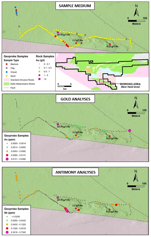
Figure 2: Geoprobe sampling results in the Bear Head Trend, including A) Sample medium, B) Gold analyses, C) Antimony analyses. Significant rock samples are labeled on the maps.
To view an enhanced version of Figure 2, please visit:
https://orders.newsfilecorp.com/files/7276/113512_capture.jpg
About The Bear Head Trend
Cross River Ventures field crews discovered the Bear Head Trend during the summer 2021 fieldwork. It is located approximately 600 meters south of the historic Chellow Vein at the southern contact between mafic volcanics and granite along the Bear Head Fault Zone (Figure 1). This geological environment is considered prospective for Archean greenstone gold deposits and contains favorable structural and lithological sites for gold deposition.
The Bear Head Trend is an undrilled, minimum 700m, high-grade gold corridor that is nested within a WNW trending multi-km braided damage zone structure. Key samples collected in 2021 include sheared and silicified mafic metavolcanic rocks with 1-10cm wide smoky blue quartz veins which returned gold values of 19.75 grams-per-tonne ("g/t") gold ("Au") and 1.415 g/t Au.
About the McVicar Project
Cross River's McVicar Gold Project is a district-scale (approximately 12,000 hectares) gold exploration project that contains gold prospective structure and host rocks that transect the entire Lang Lake greenstone belt, located in the Patricia Mining Division, approximately 150 km east of Red Lake, and 80 km west of Pickle Lake, in NW Ontario, Canada.
The McVicar project covers all the major fertile structural and lithostratigraphic elements of the greenstone belt, which is bound to the south by the major NW trending Bear Head Fault zone (within which the historic Golden Patricia Mine is situated).
Historic drilling at McVicar Lake in the Altered and North Flexure Zones includei:
6.46 g/t Au over 10.09 m including 29.86 g/t Au over 1.86 m
5.5 g/t Au over 3.6 m including 12.2 g/t Au over 0.98m
The McVicar Lake claims also host the Chellow Vein zone, which is a narrow quartz vein that consists of smoky grey to white quartz mineralized with minor pyrite and visible gold. The vein system yielded high grade gold at surface including grab samplesii that assayed 827.4 g/t Au and 578.1 g/t Auiii.
Limited drill testing below the known showings in the early 1990's didn't yield significant gold assay values; however, the Cross River technical team believe the Chellow Vein is hosted in a much broader (1-2km wide) high-strain deformation corridor, characterized by a series of parallel-trending shears that have not been systematically tested.
The 2022 winter drill program is fully funded, and the Company has received all relevant permits.
Laboratory Protocol, Quality Assessment, Quality Control
Geoprobe samples pertaining to this release were sent to ALS Geochemistry Laboratories in Thunder Bay, Ontario, for analysis. Samples were prepared using PREP-31 standard rock/core package and analyzed for gold using standard Fire Assay and ICP-AES (ALS Code: Au-ICP21). One certified gold standard and one blank were inserted for every 50 Geoprobe samples.
Qualified Person
Daniel MacNeil, P.Geo., M.Sc., a Qualified Person as defined under National Instrument 43-101, reviewed, and approved the technical content disclosed in this press release. Historical assay results contained in this press release were not verified by the Company. However, the historical reports referenced were authored by experienced geoscientists and copies of laboratory assay sheets were commonly inserted in the reports.
About Cross River Ventures
Cross River is a gold exploration company focused on the development of top tier exploration properties located in emerging Greenstone Districts of NW Ontario, Canada. The Company controls a 28,000-ha, multiple project portfolio with highly prospective ground in and among prolific, gold bearing greenstone belts. Cross River's common shares trade in Canada under the symbol "CRVC" on the CSE, and in the US under the symbol "CSRVF" on the OTCQB. Please visit www.crossriverventures.com for more information.
On behalf of the Board of Directors of
CROSS RIVER VENTURES CORP.
Alex Klenman
CEO
604-227-6610
[email protected]
www.crossriverventures.com
Neither the Canadian Securities Exchange nor its Regulation Services Provider (as that term is defined in the policies of the Canadian Securities Exchange) accepts responsibility for the adequacy or accuracy of this release.
This news release may contain forward-looking statements. These statements are based on current expectations and assumptions that are subject to risks and uncertainties. Actual results could differ materially because of factors discussed in the management discussion and analysis section of our interim and most recent annual financial statement or other reports and filings with the Canadian Securities Exchange and applicable Canadian securities regulations. We do not assume any obligation to update any forward-looking statements, except as required by applicable laws.
i McKay D.B, 2004. Report on the 2003 Overburden Stripping, Geologic Mapping and Sampling Program conducted on the McVicar Lake Property: Continuum Resources Ltd and Prospector Consolidated Resources Inc. www.geologyontario.mndm.gov.on.ca/mndmfiles/afri/data/imaging/52O11SW2003/52O11SW2003.pdf
ii Grab samples are selective by nature and may not represent the true grade or style of mineralization across the property. Daniel MacNeil, P.Geo., MSc., a Qualified Person as defined under National Instrument 43-101, reviewed, and approved the technical content disclosed in this press release. Historical assay results contained in this press release were not verified by the Company. However, the historical reports referenced were authored by experienced geoscientists and copies of laboratory assay sheets were commonly inserted in the reports.
iii Waldie C.J. Report of Diamond Drilling McVicar Lake Area Patricia Mining Division: BHP Minerals Canada Ltd. http://www.geologyontario.mndm.gov.on.ca/mndmfiles/afri/data/imaging/52O11SW0014/52O11SW0014.pdf
To view the source version of this press release, please visit https://www.newsfilecorp.com/release/113512
Please make the indicated changes including the new text: US quotes snapshot data provided by IEX. Additional price data and company information powered by Twelve Data.