
CAT Strategic Metals Launches High Resolution Drone Magnetic Survey on the Burntland Copper-Silver Project, New Brunswick
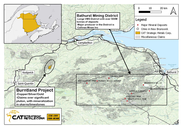
VANCOUVER, BC / ACCESSWIRE / January 25, 2021 / CAT Strategic Metals Corporation (CSE:CAT)(FRA:8CH) ("CAT" or the "Company") announces that it plans to initiate a high-resolution drone magnetic survey on the Burntland property ("Burntland" or the "Project") to be carried out in February 2021. The Burntland Project is comprised of ~1200 hectares located near the Bathurst Mining District of New Brunswick, Canada as shown in Figure 1.
Figure 1: Location of CAT's Burntland Project with respect to the Bathurst Mining DIstrict
The 975 line-kilometre high-resolution drone magnetic survey will be flown at a low elevation approximately 10 metres above the tree-line and at 25 metre line spacings, covering the entirety of the Project. The magnetic survey, flown at low altitude and lower speeds compared to conventional helicopter or fixed-wing surveys, will collect an abundance of data that will be used to identify structural features that may be related to mineralization as well as identify areas of magnetic disruption that may be related alteration associated with hydrothermal mineralizing fluids. In addition, the Company is hopeful that the survey may identify buried porphyry intrusive bodies which could be related to the source of the skarn-type mineralization that has been identified to date. The data from the survey will be used to generate a detailed structural map of the Project and will be also inverted in 3D to identify deep-seated features.
Mr Robert Rosner, CEO of CAT, commented "we are keen to begin the first phase of our 2021 work program on the Burntland Project. The high-resolution drone magnetic survey will be very useful in generating targets for follow-up trenching and drilling targets for the summer of 2021. The Burntland Project is host to high grade copper-silver skarn mineralization, and we are excited to expand upon the known mineralization as well as explore for additional areas of skarn mineralization as well as potential buried porphyry-type mineralization, which is often associated with skarn-type mineralization at many other locales around the world."
The Burntland Project was acquired by CAT in September of 2020, under an option agreement to earn up to 100%. As reported in the September 17, 2020 press release, trenching completed by the vendors in 2020 identified extensive areas of skarnified sediment-hosted mineralization adjacent to porphyry dykes. The average of 27 samples collected from this trench area returned 1.67 % Cu and 39.3 g/t Ag, with samples taken selectively across approximately 60 metres of the exposed trench. The highest grade samples from this exercise include up to 16.3 % Cu & 220.0 g/t Ag, 5.58 % Cu & 192.0 g/t Ag, and 6.2 % Cu & 118 g/t Ag. Note that rock grab samples are selective by nature and values reported may not represent the true grade or style of mineralization across the property. A historical ground magnetic survey indicates that skarn-type mineralization on the Project is often found at the margins of magnetic-high areas.
Qualified Person
Mr. Kelly Malcolm, P.Geo (Ontario), is the qualified person as defined by National Instrument 43-101 who has reviewed and approved the technical contents of this press release. The Qualified Person has not completed sufficient work to verify the historic information on the Property, particularly in regard to the neighbouring projects and historical drilling data.
ON BEHALF OF THE BOARD
Robert Rosner
Chairman, President & CEO
Further information regarding the Company can be found on SEDAR at www.SEDAR.com, or by contacting the Company directly at (604) 674-3145.
This news release may contain forward-looking statements. Forward-looking statements address future events and conditions and therefore involve inherent risks and uncertainties. Actual results may differ materially from those currently anticipated in such statements. Particular risks applicable to this press release include risks associated with planned production, including the ability of the company to achieve its targeted production outline due to regulatory, technical or economic factors. In addition, there are risks associated with estimates of resources, and there is no guarantee that are source will have demonstrated economic viability as necessary to be classified as a reserve. There is no guarantee that additional exploration work will result in significant increases to resource estimates.
Neither Canadian Securities Exchange nor its Regulation Services Provider (as that term is defined in policies of the Canadian Securities Exchange) accepts responsibility for the adequacy or accuracy of this release.
We seek safe harbour.
SOURCE: CAT Strategic Metals Corporation
View source version on accesswire.com:
https://www.accesswire.com/625637/CAT-Strategic-Metals-Launches-High-Resolution-Drone-Magnetic-Survey-on-the-Burntland-Copper-Silver-Project-New-Brunswick
Please make the indicated changes including the new text: US quotes snapshot data provided by IEX. Additional price data and company information powered by Twelve Data.