
Talon Drilling Update: Talon Intersects 5.73 Meters (18.8 Feet) of Mixed Massive Sulphides Outside of Talon's Resource Area
Road Town, Tortola, British Virgin Islands--(Newsfile Corp. - April 2, 2020) - Talon Metals Corp. ("Talon" or the "Company") (TSX: TLO) is pleased to announce that 5.73 meters (18.8 feet) of Mixed Massive Sulphides ("MMS") have been intersected and logged outside of the Company's resource area at the Tamarack Nickel-Copper-Cobalt project ("Tamarack Project"), located in Minnesota, USA. The Tamarack Project comprises the Tamarack North Project and the Tamarack South Project.
Highlights:
- 5.73 meters (18.8 feet) of MMS have been intersected in new drill hole 16TK0233C (starting at 500.45 meters) to the west of the Company's resource area (see Figures 1 & 2).
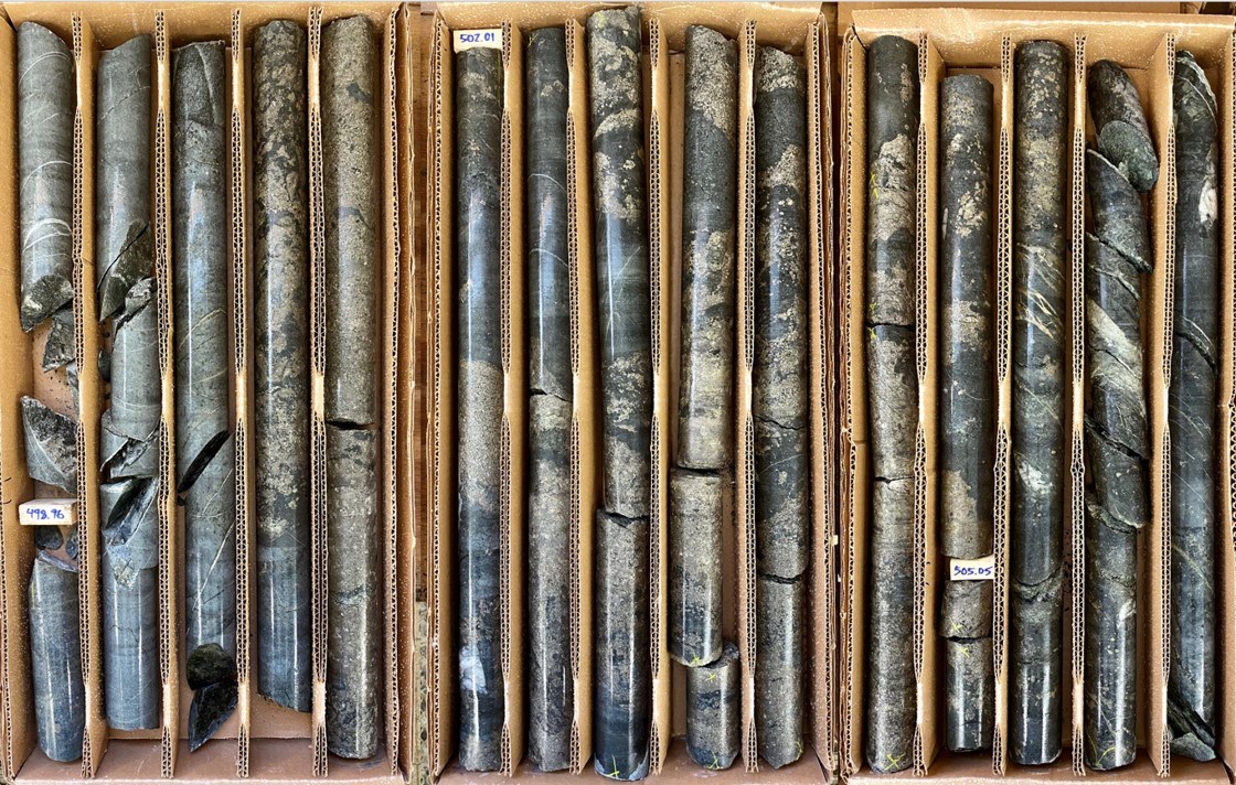
FIGURE 1: DRILL CORE FROM DRILL HOLE 16TK0233C: PHOTO FROM ~498.8 METERS TO ~506.5 METERS
To view an enhanced version of this graphic, please visit:
https://orders.newsfilecorp.com/files/2443/54067_49eb6fb86450da27_002full.jpg
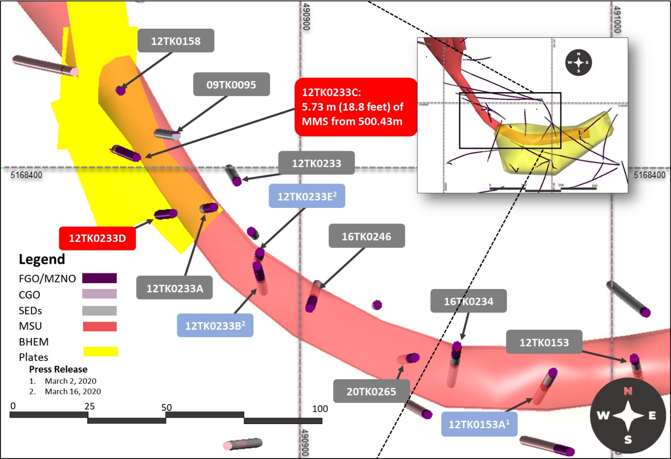
FIGURE 2: PLAN VIEW OF THE SOUTHERN PORTION OF THE HIGH-GRADE MSU WITHIN THE TAMARACK ZONE BELOW THE 138 ZONE. THE MAP SHOWS THE LOCATION OF DRILL HOLES 16TK0233C AND 16TK0233D WITH REPSECT TO THE BHEM ANOMALY AND THE HIGH-GRADE MSU RESOURCE AREA
To view an enhanced version of this graphic, please visit:
https://orders.newsfilecorp.com/files/2443/54067_49eb6fb86450da27_003full.jpg
"We are excited to report that we have intersected 5.73 meters (18.8 feet) of mixed massive sulphides outside of the Company's resource area," said Henri van Rooyen, CEO of Talon. "As previously discussed, one of the Company's goals is to grow the resource at the Tamarack Project."
"Using directional drilling, we have now shown that we are able to cost-effectively target and drill more mixed massive sulphides," said Brian Goldner, Head of Exploration of Talon (on secondment from Rio Tinto). "Because of our effective use of geological and geophysical models as well as drilling methods, we anticipate that our drill program will be completed well under budget, leaving the Company with additional cash resources."
Drill Holes: Objectives, Design and Results
The objective of drill holes 16TK0233C and 16TK0233D was to test a potential widening of the high-grade massive sulphide unit ("MSU") evidenced by two Borehole Electromagnetic ("BHEM") plates that deviate from the trend of the massive sulphide (see Figure 2). Both drill targets lie outside of the Company's resource area. Hole 16TK0233C was targeting the center of a BHEM anomaly identified from drill hole 09TK0095, whereas drill hole 16TK0233D was targeting the edge of the BHEM anomaly identified in drill hole 16TK0233A.
Drill hole 16TK0233C was designed as a wedged hole from parent hole 16TK0233 and was directionally steered onto target, which eliminated the need to drill the top 311 meters of the hole. Drill hole 16TK0233D was drilled without the use of a wedge by drilling straight through the directional curve from 16TK0233C, which eliminated the top 343 meters of the hole. If drilled from surface, these targets would have required 1141 meters of drilling, but by using directional drilling, both targets were tested with only 485 meters of core drilled.
As a result, drill hole 16TK0233C intercepted 5.73 meters (18.8 feet) of MMS (starting at 500.45 meters) 5 meters (16 feet) to the west, and outside the Company's resource area.
Drill hole 16TK0233D was also drilled outside of the Company's resource area. The hole drilled the contact of the FGO/MZNO with CGO outside the Sedimentary wedge. A BHEM survey conducted on 16TK0233D has identified a strong BHEM anomaly to the north-east, towards 16TK0233A where the Company's resource area is located. Drill hole 16TK0233A intercepted 9 meters (29.5 feet) of MMS, grading 4.94% Ni, 2.08% Cu 1.00 g/t PGE's and 0.24 g/t Au (6.12% NiEq[1]) starting at 508 meters.
We look forward to providing results from further assays and geophysical data processing and interpretation when these become available.
Quality Assurance, Quality Control and Qualified Persons
Please see the technical report entitled "NI 43-101 Technical Report Updated Preliminary Economic Assessment (PEA) of the Tamarack North Project - Tamarack, Minnesota" with an effective date of March 12, 2020 prepared by independent "Qualified Persons" (as that term is defined in National Instrument 43-101 ("NI 43-101") Leslie Correia (Pr. Eng), Andre-Francois Gravel (P. Eng.), Tim Fletcher (P. Eng.), Daniel Gagnon (P. Eng.), David Ritchie (P. Eng.), Oliver Peters (P. Eng.), Christine Pint (P.G.) and Brian Thomas (P. Geo.) for information on the QA/QC, analytical and testing procedures at the Tamarack Project. Copies are available on the Company's website (www.talonmetals.com) or on SEDAR at (www.sedar.com). The laboratory used is ALS Minerals who is independent of the Company.
Lengths are drill intersections and not necessarily true widths. True widths cannot be consistently calculated for comparison purposes between holes because of the irregular shapes of the mineralized zones. Drill intersections have been independently selected by Talon. Drill composites have been independently calculated by Talon. The geological interpretations in this news release are solely those of the Company.
The locations and distances highlighted on all maps in this news release are approximate.
Dr. Etienne Dinel, Vice President, Geology of Talon, is a Qualified Person within the meaning of NI 43-101. Dr. Dinel is satisfied that the analytical and testing procedures used are standard industry operating procedures and methodologies, and he has reviewed, approved and verified the technical information disclosed in this news release, including sampling, analytical and test data underlying the technical information.
About Talon
Talon is a TSX-listed base metals company in a joint venture with Rio Tinto on the high-grade Tamarack Nickel-Copper-Cobalt Project located in Minnesota, USA, comprised of the Tamarack North Project and the Tamarack South Project. Talon has an earn-in right to acquire up to 60% of the Tamarack Project. The Tamarack Project comprises a large land position (18km of strike length) with numerous high-grade intercepts outside of the current resource area. Talon is focussed on expanding its current high-grade nickel mineralization resource prepared in accordance with NI 43-101; identifying additional high-grade nickel mineralization; and developing a process to potentially produce nickel sulphates responsibly for batteries for the electric vehicles industry. Talon has a well-qualified mine management team with extensive experience in project management.
For additional information on Talon, please visit the Company's website at www.talonmetals.com or contact:
Sean Werger, President
Email: [email protected]
Telephone: 416-361-9636
Forward-Looking Statements
This news release contains certain "forward-looking statements". All statements, other than statements of historical fact that address activities, events or developments that the Company believes, expects or anticipates will or may occur in the future are forward-looking statements. These forward-looking statements reflect the current expectations or beliefs of the Company based on information currently available to the Company. Such forward-looking statements include statements relating to the timing and results of the exploration program, including assay results, geophysical data processing and interpretation and the ability to extend the MSU at the Tamarack Project and the anticipation that the drill program will be completed well under budget. Forward-looking statements are subject to significant risks and uncertainties and other factors that could cause the actual results to differ materially from those discussed in the forward-looking statements, and even if such actual results are realized or substantially realized, there can be no assurance that they will have the expected consequences to, or effects on the Company.
Any forward-looking statement speaks only as of the date on which it is made and, except as may be required by applicable securities laws, the Company disclaims any intent or obligation to update any forward-looking statement, whether as a result of new information, future events or results or otherwise. Although the Company believes that the assumptions inherent in the forward-looking statements are reasonable, forward-looking statements are not guarantees of future performance and accordingly undue reliance should not be put on such statements due to the inherent uncertainty therein.
Table 1: Collar Locations for Drill Holes Mentioned in Press Release
HOLEID | Easting (m) | Northing (m) | Elevation (masl) | Wedge depth (m) | Azm | Dip | End Depth |
09TK0095 | 490983 | 5168407 | 388.77 | 265.2 | -73.6 | 663.86 | |
12TK0158 | 490850 | 5168418 | 388.27 | 58.3 | -89.2 | 594.66 | |
16TK0233A | 490914 | 5168369 | 388.40 | 392.0 | 283.6 | -84.3 | 583.34 |
16TK0233B | 490914 | 5168369 | 388.40 | 339.4 | 294.1 | -83.2 | 551.08 |
16TK0233C | 490914 | 5168369 | 388.40 | 309.7 | 300.4 | -84.8 | 528.00 |
16TK0233D | 490914 | 5168369 | 388.40 | 157.4 | -89.8 | 578.51 |
Collar coordinates are UTM Zone 15N, NAD83.
Azimuth and Dip are downhole survey averages for the hole.
For daughter holes; collar coordinates and elevations are same as mother hole; approximate wedge depth given; azimuth and dip are the survey averages below the wedge.
[1] Where used un this press release NiEq% = Ni%+ Cu% x $3.00/$8.00 + Co% x $12.00/$8.00 + Pt [g/t]/31.103 x $1,300/$8.00/22.04 + Pd [g/t]/31.103 x $700/$8.00/22.04 + Au [g/t]/31.103 x $1,200/$8.00/22.04
To view the source version of this press release, please visit https://www.newsfilecorp.com/release/54067
Please make the indicated changes including the new text: US quotes snapshot data provided by IEX. Additional price data and company information powered by Twelve Data.