
Japan Gold Announces Encouraging Results from Geochemical & Geophysical Surveys Identifying Additional Drill Targets at the Ohra-Takamine Gold Project
Vancouver, British Columbia--(Newsfile Corp. - June 11, 2020) - Japan Gold Corp (TSXV: JG) (OTCQB: JGLDF) ("Japan Gold" or "the Company") is pleased to announce encouraging results from geochemical and geophysical surveys at the Ohra-Takamine Gold Project in southern Kyushu. Mutually supporting results from soil and rock geochemistry, spectral alteration analysis, and geophysical gravity data processed for structure detection have defined five new anomalous zones along strike of and parallel to the Ohra-Takamine-Urushi mine corridor. These results coincide with anomalies previously defined by CSAMT geophysical survey data, released in the Company's April 8, 2020 news release.
Highlights:
- Five new anomalous exploration targets defined by grid-based geochemical and geophysical programs
- New anomalies up to 2.5 km in strike length, occur both along strike and parallel to the mineralized Ohra-Takamine-Urushi mine corridor, three of which remain open-ended along strike
- Structure detection from processed gravity data along with geochemistry is defining vectors to potentially mineralized targets under post mineral cover
- CSAMT resistivity anomalies correlate well with gold and pathfinder element anomalism along the mine corridor and further validate drill targets
"The definition of these new exploration targets, revealing both strike extensions to the known mines, and new parallel zones, is highly encouraging and validates our exploration methodology. These results further support our CSAMT defined geophysical targets. We will now rank all targets and advance the first phase of our scout drilling program", stated John Proust, Chairman and CEO.
The Ohra-Takamine Gold Project lies within the highly gold endowed Southern Kyushu Epithermal Gold Province, from which more than 11 million ounces of gold have been produced from high-grade epithermal gold deposits. This Project hosts five historic gold mines, the Matsuno, Urushi, Takamine, Ohra, and Aira Yamada Mines, defining a northeast oriented structural corridor (Figure 1).
Grid based soil-sampling, analysed for gold and other pathfinder elements and by spectral alteration mineral analysis, has defined five areas of geochemical and alteration anomalies. These anomalies define strike extensions, up to 2.5 kms long, northeast of the Ohra mine and new parallel zones within the mine corridor area (Figures 2 to 5). Deeper structures interpreted from processed gravity (Figure 6) and CSAMT resistivity data coincide with the geochemical and alteration anomalies and potentially define the location and geometry of mineralised faults (Figure 7). The Company's rationale for identifying drill targets is based on this multi-faceted approach.
Drill permits previously received from the Ministry of Economy Trade and Industry ("METI") for the Ohra-Takamine project will allow drilling to commence shortly. Permitting for drill holes to test the other new targets is in progress.
Soil and Rock Sampling and Clay Alteration Analysis
A 6.4 km long, and 3.3 km wide soil sample grid covering the Ohra-Takamine-Urushi area was completed early in 2020 (Figure 1). Composite soil samples were collected at 50 m spacings along 33 individual, north-south orientated grid lines, located 200 m apart. Multi-element geochemical assay and clay spectral analysis were completed on 1,470 composite soil samples and 188 accompanying rock-chip samples. Geological and alteration mapping completed in parallel with the soil sampling program has also been compiled and merged with the data set.
Processed Gravity Data
Bouguer gravity data collected by Haines Surveys Pty Ltd, over an approximate 8 by 4 km area, was merged with regional Geological Survey of Japan gravity data. Fathom Geophysics re-processed the merged data set to enhance rapid changes in gravity gradient. The resulting imagery aids in detection of under-cover or deep-seated basement structures not obvious at surface (Figure 6).
Conclusions from Geophysics, Soil and Rock Geochemistry and Alteration
Soil results confirm the presence of gold and silver in soil anomalism across and around the known historical Ohra, Takamine and Urushi mine workings (Figures 2 to 5). Anomalous gold in soil along the mine corridor correlates well with elevated levels of the important pathfinder elements, antimony and arsenic. Collectively, gold, silver, mercury, antimony and arsenic provide excellent vectors to lesser explored and understood, high-level alteration zones present to the north and south, and along strike, of the mine corridor.
CSAMT and Soil Anomalies
Northeast trending gold soil anomalies coincident with other pathfinder elements have been identified overlying contiguous linear zones of high CSAMT resistivity at the Ohra-Takamine Project. Japan Gold is targeting its forthcoming drilling program based on integration of these geochemical, geophysical and geological datasets.
Sampling Techniques and Assaying
Soil sample results presented in this news release and accompanying figures were collected on north-south grid lines grid using pre-determined GPS points. Spacing between lines was 200 m with composite samples collected 12.5 meters either side of 50-meter spaced centroids. At each location a "B to C Horizon" soil sample was collected using a crow-bar or shovel at depths ranging from 15 to 50 cm, composite sample weights were a nominal 1 kilogram. The samples were placed into numbered calico sample bags, registered, boxed, sealed and stored in company premises prior to being sent for analysis. Sample preparation and assaying were done by ALS Vancouver, BC, Canada. Samples were crushed and pulverised, gold and a 48 multi-element suit was analysed by aqua regia with an ICP-MS finish.
Rock results presented in this news release and accompanying figures are from 1-3 kg selected grab of outcrop, mine dump, sub-crop and float samples. The grab samples of float and dump material reported in this announcement are believed to originate from the underlying bedrock. The Company cautions that grab samples are selective by nature and may not be representative of typical mineralization on the property. Sample preparation and assaying were done by ALS Vancouver, BC, Canada. Samples were Samples were crushed and pulverised and gold was analysed by 50 gram-charge Fire Assay and AAS finish. A 48 multielement analysis including silver was done by four-acid digest and ICP-MS determination.
A Chain-of-Custody was established between the Company and receiving laboratory to ensure the integrity of the samples during transportation from site to the lab.
Certified Reference Materials (CRMs) were inserted by Japan Gold at every 20th sample to assess repeatability and assaying precision of the laboratory. In addition, the laboratory applied its own internal Quality Control procedure that includes sample duplicates, blanks & geochemical standards. They report these results with the certified Assay Report. Laboratory procedures and QAQC protocols adopted are considered appropriate. The CRMs and internal QC-QA results fall within acceptable levels of accuracy & precision and are considered to lack any bias.
ALS completed a spectral scan using a Terraspec 4 HR spectrometer on the crush rejects of each soil and rock sample. Plus Minerals LLC provided analysis and interpretation on the ASD files provided by ALS. Soil spectral data needs to be carefully interpreted because illite, smectite and kaolinite wavelengths in the spectra may in some cases overlap leading to imprecise data. To overcome this inherent limitation of weak soil spectra, clay alteration zonation in this news release was interpreted using mica crystallinity ratios or reflectance (the H20 / Al-OH ratio).
Qualified Person
The technical information in this news release has been reviewed and approved by Japan Gold's Vice President of Exploration and Country Manager, Andrew Rowe, BAppSc, FAusIMM, FSEG, who is a Qualified Person as defined by National Instrument 43-101.
On behalf of the Board of Japan Gold Corp.
"John Proust"
Chairman & CEO
About Japan Gold Corp.
Japan Gold Corp. is a Canadian mineral exploration company focused solely on gold exploration across the three largest islands of Japan: Hokkaido, Honshu and Kyushu. The Company has a country-wide alliance with Barrick Gold Corporation to jointly explore, develop and mine certain gold mineral properties and mining projects. The Company holds a portfolio of 30 gold projects which cover areas with known gold occurrences, a history of mining and are prospective for high-grade epithermal gold mineralization. Japan Gold's leadership team represent decades of resource industry and business experience, and the Company has recruited geologists, drillers and technical advisors with experience exploring and operating in Japan. More information is available at www.japangold.com or by email at [email protected]
For further information, please contact:
John Proust
Chairman & CEO
Phone: 778-725-1491
Email: [email protected]
Cautionary Note
Neither the TSX Venture Exchange nor its Regulation Services Provider (as such term is defined in the policies of the TSX Venture Exchange) accepts responsibility for the adequacy or accuracy of this release. This news release contains forward-looking statements relating to expected or anticipated future events and anticipated results related to future partnerships and the Company's 2020 gold exploration program. These statements are forward-looking in nature and, as a result, are subject to certain risks and uncertainties that include, but are not limited to, general economic, market and business conditions; competition for qualified staff; the regulatory process and actions; technical issues; new legislation; potential delays or changes in plans; working in a new political jurisdiction; results of exploration; the timing and granting of prospecting rights; the Company's ability to execute and implement future plans, arrange or conclude a joint-venture or partnership; and the occurrence of unexpected events. Actual results achieved may differ from the information provided herein and, consequently, readers are advised not to place undue reliance on forward-looking information. The forward-looking information contained herein speaks only as of the date of this News Release. The Company disclaims any intention or obligation to update or revise forward‐looking information or to explain any material difference between such and subsequent actual events, except as required by applicable law.

Figure 1. Ohra-Takamine Gold Project, Soil grid, CSAMT and gravity geophysical survey locations on geology.
To view an enhanced version of this graphic, please visit:
https://orders.newsfilecorp.com/files/5665/57688_badbc7b3e4668a12_001full.jpg
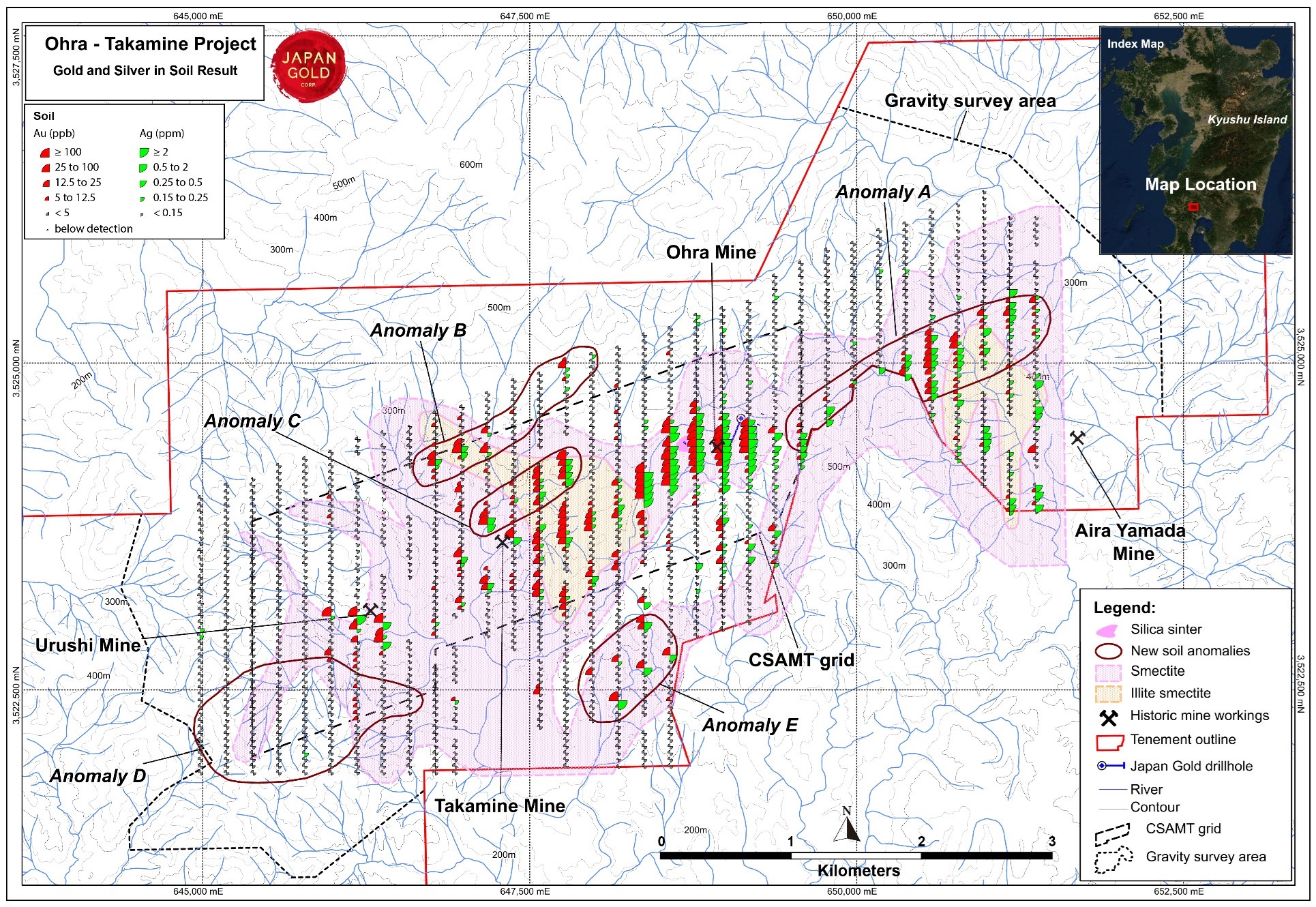
Figure 2. Ohra-Takamine Gold Project, Gold & Silver in soil anomalies with alteration and Structure-Geochem coincident anomalies
To view an enhanced version of this graphic, please visit:
https://orders.newsfilecorp.com/files/5665/57688_badbc7b3e4668a12_002full.jpg

Figure 3. Ohra-Takamine Gold Project, Gold & Mercury in soil anomalies with alteration and Structure-Geochem coincident anomalies
To view an enhanced version of this graphic, please visit:
https://orders.newsfilecorp.com/files/5665/57688_badbc7b3e4668a12_003full.jpg

Figure 4. Ohra-Takamine Gold Project, Gold & Antimony in soil anomalies with alteration and Structure-Geochem coincident anomalies
To view an enhanced version of this graphic, please visit:
https://orders.newsfilecorp.com/files/5665/57688_badbc7b3e4668a12_004full.jpg
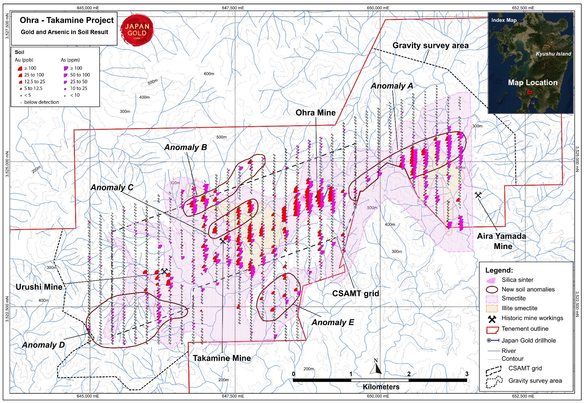
Figure 5. Ohra-Takamine Gold Project, Gold & Arsenic in soil anomalies with alteration and Structure-Geochem coincident anomalies
To view an enhanced version of this graphic, please visit:
https://orders.newsfilecorp.com/files/5665/57688_badbc7b3e4668a12_005full.jpg

Figure 6. Ohra-Takamine Gold Project, processed gravity with edge detection for structure definition and gold / antimony soil anomalies. Red lines on the gravity image represent contoured gravity gradients and define linear features interpreted to represent basement off-sets and major structures
To view an enhanced version of this graphic, please visit:
https://orders.newsfilecorp.com/files/5665/57688_badbc7b3e4668a12_006full.jpg

Figure 7. Ohra-Takamine Gold Project, CSAMT stacked pseudo-sections with mine locations and gold / antimony soil anomalies.
To view an enhanced version of this graphic, please visit:
https://orders.newsfilecorp.com/files/5665/57688_badbc7b3e4668a12_007full.jpg
![]()
To view the source version of this press release, please visit https://www.newsfilecorp.com/release/57688
Please make the indicated changes including the new text: US quotes snapshot data provided by IEX. Additional price data and company information powered by Twelve Data.