
Golden Ridge Continues to Drill Near Surface Silver and Gold Mineralization at the Heritage Project; Hole HE-EZ-20-05 Intersects 24.20 Metres of 122.67 g/t AgEq
(TheNewswire)

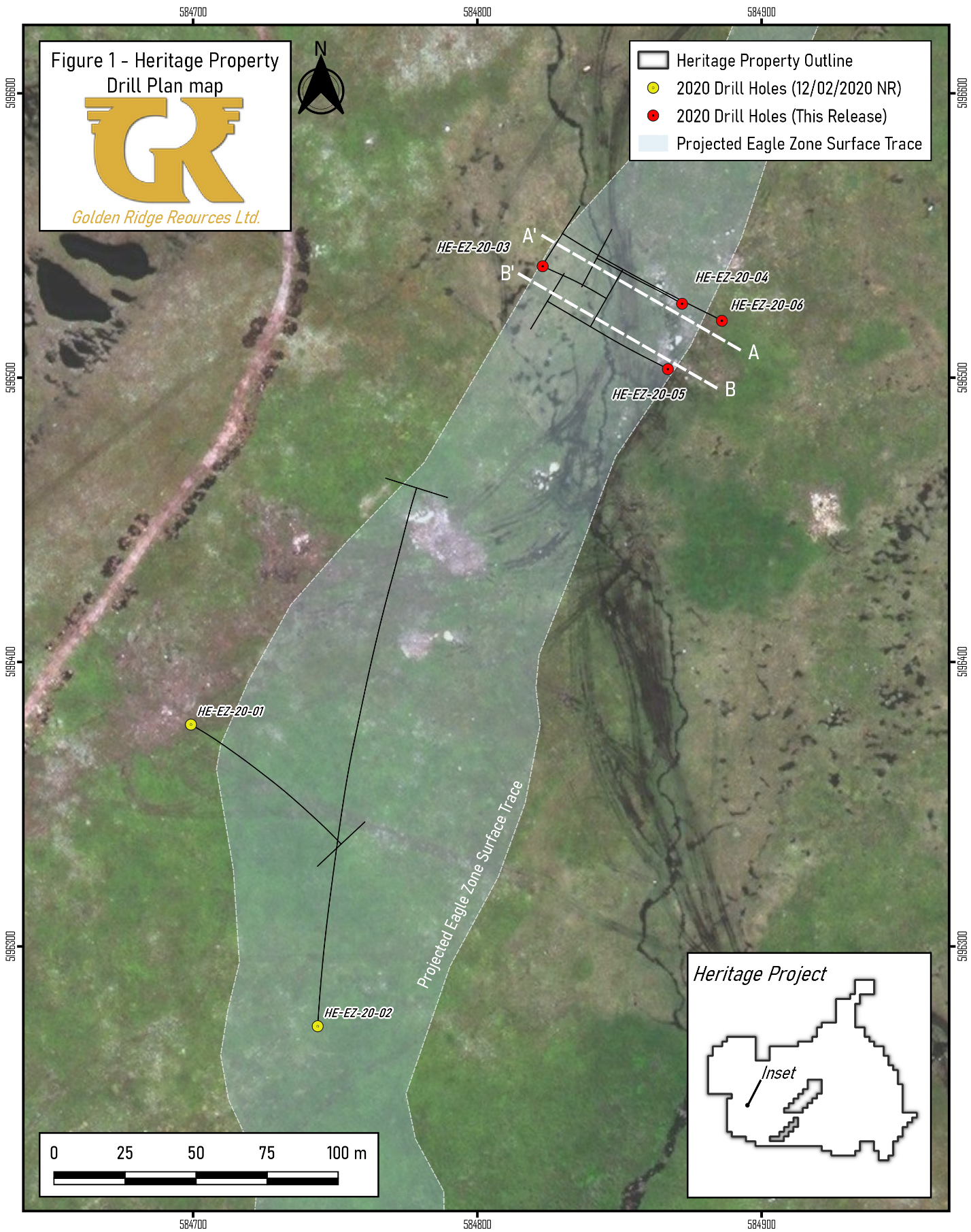
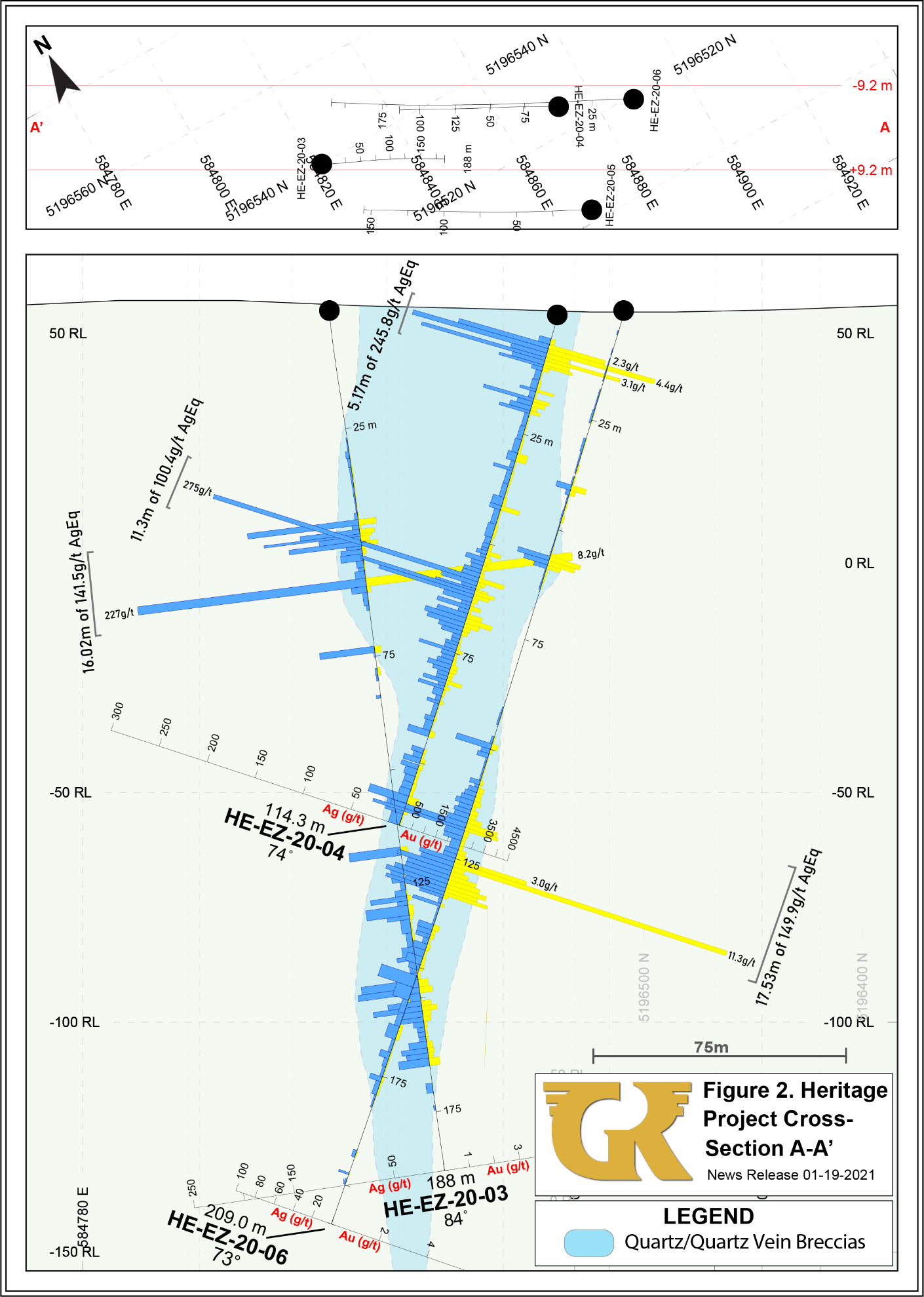
Kelowna, British Columbia - TheNewswire - January 19, 2021 - Golden Ridge Resources Ltd. (“Golden Ridge” or the “Company”) (TSXV:GLDN) (OTC:GORIF) is very pleased to announce results from holes HE-EZ-20-03 to HE-EZ-20-6 at the Eagle Zone, drilled as part of the Company’s ongoing 5,000 metre diamond-drill program at the Heritage epithermal Ag-Au project, located along Highway 220, near Point May, Newfoundland and Labrador. Holes HE-EZ-20-03 to HE-EZ-20-06 were designed to extend epithermal Ag-Au mineralization at the Eagle Zone, along strike and at depth. All four holes hit significant intersections of epithermal veining, alteration, ginguro textures and Ag-Au mineralization. Drilling thus far at the Eagle Zone has delineated a robust epithermal system of continuous Ag-Au mineralization at least 750 meters in length, 50 meters in width and 250 meters in depth. The central core of the Eagle zone contains bonanza-grade Ag-Au veining which may represent one of several discrete boiling zones within the system.
Holes HE-EZ-20-03 to HE-EZ-20-06 were drilled approximately 280 meters northeast of Hole HE-EZ-20-02 (see GLDN press release dated December 2, 2020). A drilling plan view map (Figure 1) and cross-sections (Figures 2 & 3) are presented below and have also been posted to the Company’s website.
Highlights
-
-- HE-EZ-20-05 shows lateral continuity with the high-grade Ag-Au mineralization within the central part of the Eagle Zone, including multiple intervals of robust epithermal boiling-zone alteration and mineralization.
-
-- Holes HE-EZ-20-03 to HE-EZ-20-06 successfully extended one of the high-grade Ag-Au boiling zones within the central part of the Eagle Zone, laterally and to 200 meters true vertical depth.
-
-- Drilling continues to intersect epithermal-style alteration and mineralization at depth within the Eagle Zone, where historic drilling was focused on depths of less than ~100 meters.
-
-- Ongoing drilling at the Eagle Zone will aim to further increase its dimensions, along strike and at depth.
-
-- Drilling continues to identify key mineralizing structures which will aid future exploration outside the Eagle Zone.
Table 1 – Significant Intercepts
|
HOLE ID |
FROM (M) |
TO (M) |
INTERVAL (M)2 |
Au (g/t) |
Ag (g/t) |
AuEq (g/t) |
AgEq (g/t) |
AuEq Gram Meter |
|
HE-EZ-20-03 |
45.00 |
164.94 |
119.94 |
0.22 |
16.08 |
0.43 |
32.62 |
52.04 |
|
Including |
45.00 |
61.02 |
16.02 |
1.14 |
55.83 |
1.88 |
141.54 |
30.16 |
|
And |
57.85 |
59.65 |
1.80 |
8.22 |
227.20 |
11.24 |
845.25 |
20.24 |
|
And |
116.85 |
164.94 |
48.09 |
0.16 |
19.42 |
0.42 |
31.45 |
20.12 |
|
HE-EZ-20-04 |
3.35 |
114.32 |
110.97 |
0.28 |
19.37 |
0.54 |
40.42 |
59.66 |
|
Including |
4.64 |
69.00 |
64.36 |
0.39 |
23.87 |
0.71 |
53.19 |
45.53 |
|
Including |
4.64 |
9.81 |
5.17 |
2.21 |
79.67 |
3.27 |
245.84 |
16.90 |
|
And |
57.70 |
69.00 |
11.30 |
0.53 |
60.50 |
1.33 |
100.35 |
15.08 |
|
HE-EZ-20-05 |
4.40 |
129.80 |
125.40 |
0.36 |
19.47 |
0.62 |
46.54 |
77.62 |
|
Including |
4.40 |
75.00 |
70.60 |
0.58 |
21.55 |
0.87 |
65.16 |
61.18 |
|
Including |
32.13 |
33.74 |
1.61 |
3.43 |
324.69 |
7.75 |
582.58 |
12.47 |
|
And |
50.80 |
75.00 |
24.20 |
1.29 |
25.68 |
1.63 |
122.67 |
39.48 |
|
Including |
66.89 |
75.00 |
8.11 |
2.88 |
35.39 |
3.35 |
251.93 |
27.17 |
|
HE-EZ-20-06 |
39.79 |
197.64 |
157.85 |
0.24 |
9.04 |
0.36 |
27.09 |
56.86 |
|
Including |
108.80 |
157.50 |
48.70 |
0.63 |
22.23 |
0.93 |
69.60 |
45.08 |
|
Including |
115.80 |
133.33 |
17.53 |
1.49 |
37.83 |
1.99 |
149.86 |
34.94 |
|
And |
124.92 |
133.33 |
8.41 |
2.58 |
48.22 |
3.22 |
242.20 |
27.09 |
|
Including |
125.82 |
126.83 |
1.01 |
11.36 |
33.50 |
11.81 |
887.64 |
11.92 |
1 Gold (AuEq) and silver (AgEQ) equivalent grades are calculated using 100-day moving-average metal prices of gold at US$1,898.10/oz. and silver at US$25.24/oz. Gold equivalent grade is calculated as AuEq (g/t) = Au (g/t) + Ag (g/t) * 0.0133. Silver equivalent grade is calculated at AgEq (g/t) = Ag (g/t) + Au (g/t) / 0.0133. The factors for gold (0.0133) and silver (0.0133) will change depending on the metal price. The metal price numbers listed above were used to determine the conversion factors presented herein. Metal recoveries have not been applied in the gold-equivalent calculation.
2 The intervals reported in these tables represent drill intercepts and insufficient data are available at this time to state the true thickness of the mineralized intervals. All gold values are uncut.
Click Image To View Full Size
Click Image To View Full Size
Click Image To View Full Size
Table 2 – Collar locations for the Eagle Zone
|
HOLE ID |
EASTING (NAD27, Zone 21) |
NORTHING (NAD27, Zone 21) |
AZIMUTH |
INCLINATION |
|
HE-EZ-20-01 |
584699 |
5196378 |
120° |
-75° |
|
HE-EZ-20-02 |
584744 |
5196272 |
004° |
-55° |
|
HE-EZ-20-03 |
584823 |
5196539 |
114° |
-84° |
|
HE-EZ-20-04 |
584872 |
5196526 |
300° |
-74° |
|
HE-EZ-20-05 |
584867 |
5196503 |
300° |
-75° |
|
HE-EZ-20-06 |
584886 |
5196520 |
300° |
-73° |
|
HE-EZ-20-07 |
584900 |
5196516 |
300° |
-73° |
|
HE-EZ-20-08 |
584702 |
5196390 |
120° |
-70° |
|
HE-EZ-20-09 |
584699 |
5196423 |
103° |
-75° |
|
HE-EZ-20-10 |
584564 |
5196409 |
120° |
-45° |
|
HE-EZ-20-11 |
584436 |
5196248 |
115° |
-45° |
|
HE-EZ-20-12 |
584393 |
5196078 |
120° |
-45° |
|
HE-TZ-20-01 |
585194 |
5195830 |
300° |
-84° |
|
HE-PZ-20-01 |
584709 |
5195027 |
10° |
-55° |
|
HE-PZ-20-02 |
584722 |
5195057 |
30° |
-55° |
|
HE-PZ-20-03 |
584777 |
5195155 |
30° |
-45° |
|
HE-LZ-20-01 |
584810 |
5195245 |
30° |
-50° |
|
HE-LZ-20-02 |
584923 |
5195388 |
46° |
-45° |
|
HE-EZ-20-13 |
584774 |
5196321 |
11° |
-60° |
|
HE-EZ-20-14 |
584692 |
5196417 |
120° |
-70° |
|
HE-EZ-20-15 |
584907 |
5196517 |
275° |
-70° |
|
HE-EZ-20-16 |
584887 |
5196639 |
120° |
-65° |
|
HE-EZ-20-17 |
584893 |
5196660 |
120° |
-65° |
|
HE-EZ-20-18 |
584913 |
5196677 |
120° |
-65° |
|
HE-EZ-20-19 |
584893 |
5196660 |
120° |
-84° |
|
HE-EZ-20-20 |
584934 |
5196725 |
120° |
-65° |
|
HE-EZ-20-21 |
584922 |
5196709 |
120° |
-65° |
|
HE-EZ-20-22 |
584803 |
5196516 |
120° |
-65° |
“Widespread epithermal-style alteration found across the 21,613 hectare Heritage Project indicates the presence of a large, district scale gold-silver camp at Point May. The Eagle Zone appears to be part of a much larger epithermal system, which is mostly masked by flat, overburden-covered topography. The Eagle Zone has so far demonstrated consistent grade and continuity, with no evidence of significant post-mineralization faulting. A total of 17 prospects and mineralized zones have now been delineated across a 4.5 kilometer strike length from the Eagle Zone. Our exploration team continues to work up these additional target zones, towards their being drill-ready for the 2021 season. Over 80% of the project area remains to be explored, including some very conspicuous and encouraging structural extensions of the Eagle Zone which were recently revealed by an airborne magnetic survey conducted by the Company in 2020” stated Golden Ridge CEO, Michael Blady
A total of 5,061 metres have been completed during the ongoing 2020/21 drill campaign in 27 drill holes. Assays from the remaining holes are pending and they will be released to the market once received and compiled.
The Company has recently completed a comprehensive sampling program to better understand the soil response to the Eagle Zone and the surrounding target areas. Results from this survey will help the Company locate additional epithermal-style mineralization and will be released to the market once received and interpreted.
Qualified Person:
Dr. Stephen Amor, PhD, PGeo, technical advisor to the Company, is the Qualified Person as defined by National Instrument 43-101 who has reviewed and approved the technical data in this news release.
Acknowledgments:
Golden Ridge Resources acknowledges the financial support of the Junior Exploration Assistance Program, Department of Natural Resources, Government of Newfoundland and Labrador.
About Golden Ridge Resources:
Golden Ridge is a TSX-V listed exploration company engaged in acquiring and advancing mineral properties located in British Columbia and Newfoundland. Golden Ridge owns a 100% interest in the 1,700-hectare Hank copper-gold-silver-lead-zinc property located in the Golden Triangle district, approximately 140 kilometres north of Stewart, British Columbia and has a portfolio of exploration projects in Newfoundland.
Golden Ridge Resources Ltd.
Mike Blady
Chief Executive Officer
Tel: (250) 768-1168
Website: www.goldenridgeresources.com
Cautionary Note Regarding Forward-Looking Statements
Certain statements contained in this news release, constitute "forward-looking information" as such term is used in applicable Canadian securities laws. Forward-looking information is based on plans, expectations and estimates of management at the date the information is provided and is subject to certain factors and assumptions, including: that the Company's financial condition and development plans do not change as a result of unforeseen events, that the Company obtains required regulatory approvals, that the Company continues to maintain a good relationship with the local project communities. Forward-looking information is subject to a variety of risks and uncertainties and other factors that could cause plans, estimates and actual results to vary materially from those projected in such forward-looking information. Factors that could cause the forward-looking information in this news release to change or to be inaccurate include, but are not limited to, the risk that any of the assumptions referred to prove not to be valid or reliable, which could result in delays, or cessation in planned work, that the Company's financial condition and development plans change, delays in regulatory approval, risks associated with the interpretation of data, the geology, grade and continuity of mineral deposits, the possibility that results will not be consistent with the Company's expectations, as well as the other risks and uncertainties applicable to mineral exploration and development activities and to the Company as set forth in the Company's Management’s Discussion and Analysis reports filed under the Company's profile at www.sedar.com. There can be no assurance that any forward-looking information will prove to be accurate, as actual results and future events could differ materially from those anticipated in such statements. Accordingly, the reader should not place any undue reliance on forward-looking information or statements. The Company undertakes no obligation to update forward-looking information or statements, other than as required by applicable law.
Neither the TSX Venture Exchange nor its Regulation Services Provider (as that term is defined in the policies of the TSX Venture Exchange) accepts responsibility for the adequacy or accuracy of this release.
Copyright (c) 2021 TheNewswire - All rights reserved.
Please make the indicated changes including the new text: US quotes snapshot data provided by IEX. Additional price data and company information powered by Twelve Data.