
Cardero Files Drill Permit Applications for Northeast Anomaly at the Zonia Copper Oxide Deposit
Vancouver, British Columbia--(Newsfile Corp. - April 12, 2018) - Cardero Resource Corp. ("Cardero" or the "Company") (TSXV: CDU) (FSE: CR5) pleased to announce it has filed drill permits with the Bureau of Land Management (BLM) and the State of Arizona in preparation of a 5000 metre drill programme testing the Northeast Anomaly, on the Company's Zonia Copper Oxide property ("Zonia"), located in Yavapai County, Arizona USA (Figure 1).
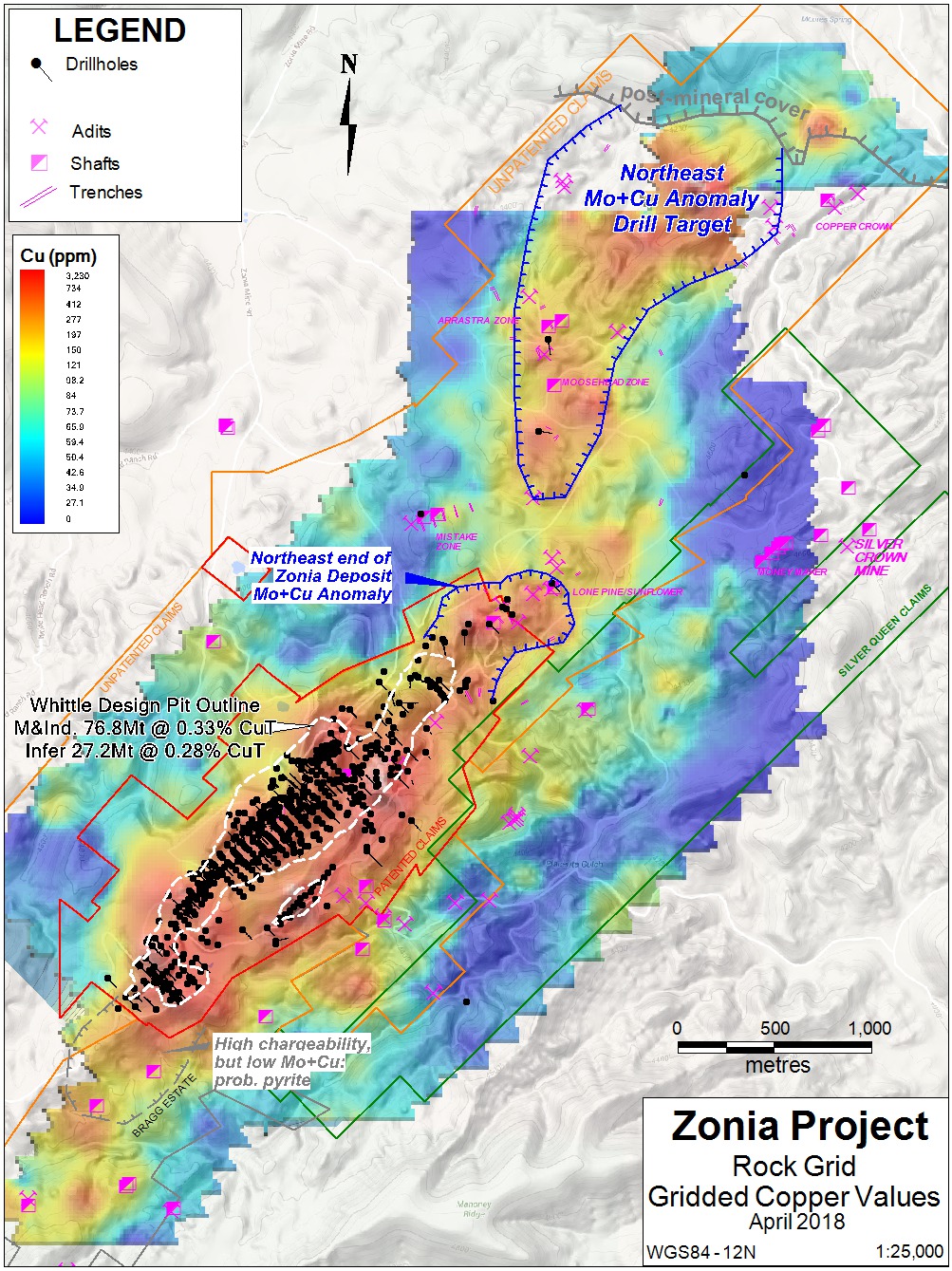
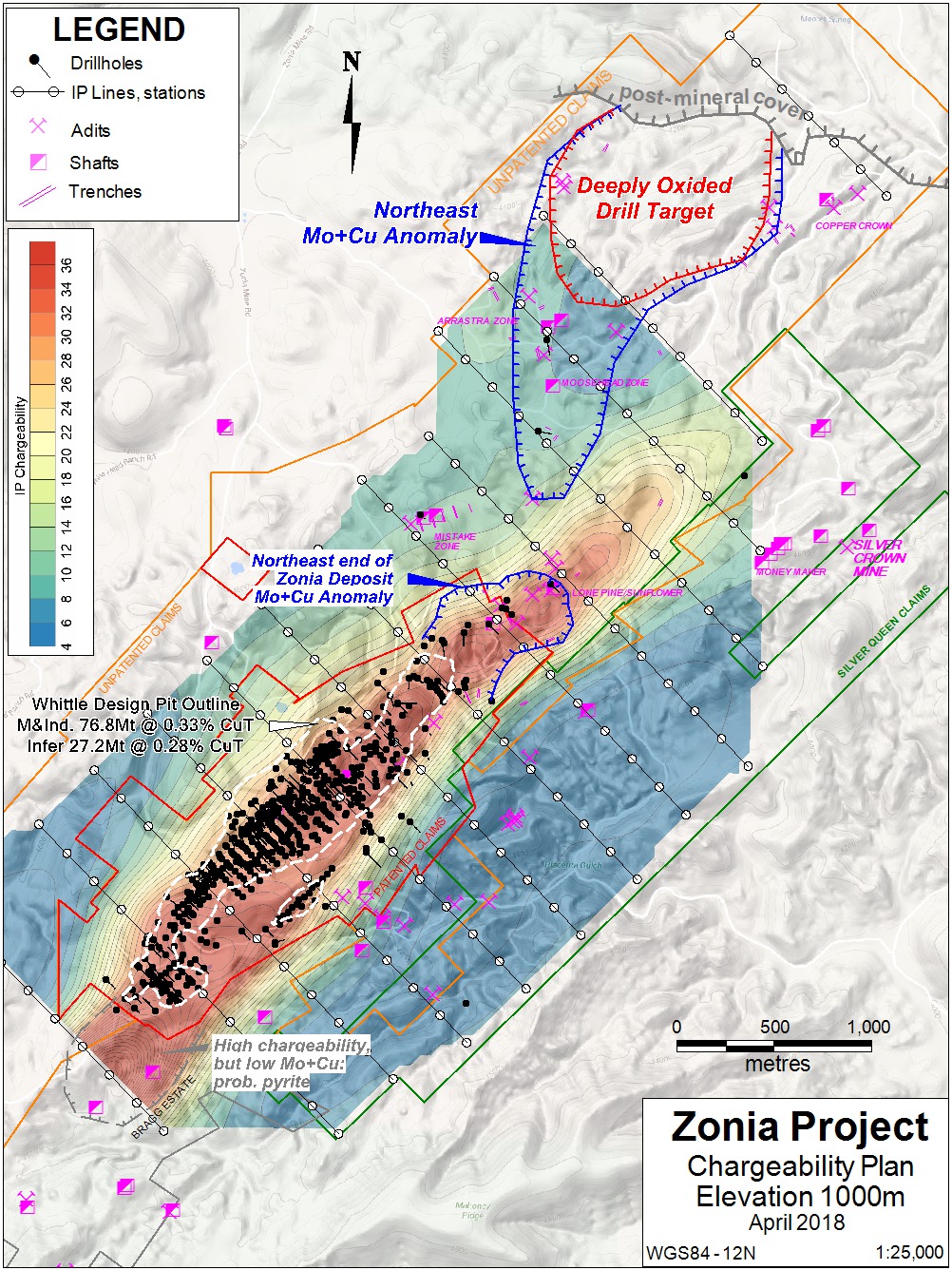
Cardero also announces receipt of data for a 28 line-kilometre Induced Polarization and Resistivity geophysical survey (the "Survey") over the Zonia and contiguous Silver Queen properties ("the Zonia project"), utilizing 200 metre spaced dipoles. Results of the Survey outline an area of overlapping chargeability and copper-molybdenum anomalies at the northeast end of the current drill-defined resource estimate (Figure 2) that could extend resources significantly. Estimated resources at Zonia are constrained by a Whittle® pit shell and were reported in November, 2017 in the Company's news release NR17-08.
"The drill plan for the Northeast target we describe below has the strong possibility of significantly increasing copper resources at Zonia. In addition, the geophysical results from the northeast end of the main deposit give us confidence we can increase mine life shown in the Company's PEA published in March 2018," stated Stuart Ross CEO of the Company.
Northeast Geochemical Anomaly Drill Plan
The northern geochemical anomaly is an area of coincident, surface rock molybdenum and copper anomalies, with depressed manganese, covering an area of 2500 by 1000 metres (previous news release NR18-03). The northern, wider half will be drill tested as a porphyry copper target. The area is believed to be deeply oxidized (see geophysical discussion below).
Cardero plans to drill a total of 5000 metres over the anomaly. The area is covered by both federal BLM and ASTL and requires separate permit applications to the state and federal agencies. Permit applications were filed to the ASTL in March and to the BLM in April.
Figure 1: Plan of gridded copper values from project-wide rock sampling, showing location of existing and proposed drill holes. All claims shown are owned or under option by Cardero.

To view an enhanced version of Figure 1, please visit:
http://orders.newsfilecorp.com/files/743/34011_a1523570168548_95.jpg
Figure 2: Plan of chargeability (mV/V) at 1000m elevation slice, Zonia main deposit area, with the Whittle pit outline that defines the current resource estimate at Zonia.

To view an enhanced version of Figure 2, please visit:
http://orders.newsfilecorp.com/files/743/34011_a1523570168985_1.jpg
Geophysical Survey Details
In January and February 2018, HydroGEOPHYSICS, Inc. (HGI), of Tucson, Arizona completed an Induced Polarization ("IP") and Electrical Resistivity ("ER") geophysical characterization on the Zonia project (Figure 1). Coincident IP and ER data were collected to characterize the extent of chargeable sulfides under the area of drill-defined mineralization, and then apply this information to outline other possible subsurface mineralization on the property. The IP method was selected to take advantage of the charge-storage capability of the sulfides that are known to underlie the copper oxide resources. ER measurements were recorded coincident with the IP measurements during this survey, as the ER data provides valuable context for the IP data and information on subsurface structure.
Thirteen lines of coincident ER and IP data, for a total of 28 line-kilometers of surveyed coverage, were collected using the dipole-dipole electrode configuration (or array). The data were collected at 200 meter (n = 1) dipole spacing, to a maximum n = 6 spacing between measurements. Seven transmitting electrode locations were constructed along each survey line. The center transmitter (TX 4) was located in the center of the line except where road access necessitated adjusting TX 4 to one or two dipole lengths off-centre of the line.
Data were collected using a LRS Scintrex IPR-12 TD IP/ER receiver system. The alternating current was transmitted by a TSQ-3 Time and Frequency Domain IP and ER Transmitter. Positional data were acquired via a handheld GPS to record the location of survey lines and track survey progress, as well as produce preliminary model results. Start and endpoints were collected along the lines with a handheld Garmin GPS. Following field data collection, the raw ER and IP data files were transmitted to the HGI server located in Tucson, Arizona, where RES2DINVx64 software (Geotomo, Inc.) was used for inverting individual lines in two dimensions. The inverted data were gridded and color contoured in Surfer (Golden Software, Inc.). RES3DINVx64 software was also used for inverting combined 2D line data in three dimensions, which were then gridded in Rockworks (Rockware, Inc.) for preliminary 3D visualization. Horizontal slices of the 3D model were then exported at 50m intervals between 1000 and 1400 metres above mean sea level, and color contoured in Surfer.
Depth slices at the 1,100, 1,200, and 1,300-meter elevations show an increase in chargeability with depth, matching observations in the drill holes of sulphides underlying the copper oxide mineralization in this area. The IP response increases in magnitude in the depth slice from the 1,100-meter elevation, with the highest values towards the southwest end of the survey area. The chargeable body is clearly observed trending across the survey area in a NE-SW direction, with highest magnitude IP responses noted in the southwest and the response dropping off toward the northeast. The top of sulphides (or base of oxidation) is known from the drilling to dip down to the northeast, and this is well reflected in the IP data.
The area of overlapping chargeability and copper-molybdenum anomalies extends about 600 metres from the current Whittle pit defined resources. Half of this area has been sparsely drilled by holes targeting copper-gold structures, with the southeast half (up-dip from the chargeability) untested. This area will be tested during the future feasibility study in-fill drill programme.
The Northeast geochemical anomaly was only covered at its margins by widely spaced lines, which did not detect sulphides (i.e. a chargeability anomaly) down to depths of 300 metres. This suggests the area is deeply weathered and a good copper oxide porphyry target.
Zonia Copper Oxide Deposit
The Zonia Copper Oxide Project has been held under private ownership for almost 100 years and has undergone comprehensive exploration, metallurgical studies and mine development planning. The majority of the mineralized area was pre-stripped during previous open-pit mining operations at Zonia in 1966, as 17 million tons were mined with 7 million tons stacked on heap leach pads, producing cement copper up till 1975. The property has been drill tested with almost 700 drill holes (60,000 meters). This high-density drilling covers 30% of the property and defines the current resource estimate, reducing technical risk on the deposit.
The Zonia copper deposit has a north-easterly strike length of about 2,400 m (8,000 ft) and horizontal width varies from 60 m (200 ft) to 460m (1,500 ft). The deposit consists of multiple mineralized zones that dip at various angles to the northwest. The zones are generally in the order of 200 ft (60 m) wide and commonly occur in sub-parallel groups of three or more. Most of the deposit has been drilled to depths of 120 m (400 ft) or less. Deposit highlights include:
- Measured and Indicated Resources of 76.8 million short tons grading 0.33% copper containing 510 million pounds of copper (0.2% copper cut-off grade).
- Inferred Resources of 27.2 million short tons grading 0.28% copper containing 154.6 million pounds of copper (0.2% copper cut-off grade).
- Low strip ratio of 1:1 waste to mineralized material in base case.
A Preliminary Economic Assessment (PEA) was completed in March, 2018. The base case uses a $2.00/lb designed pit shell with a grade cut-off of 0.17% total copper. At a copper price of $3.00/lb the economics are:
- After-tax NPV of $192 million @ 8% and an IRR of 29 %, post-tax, with a 2.89 year payback of initial capital
- Initial capital of $198 million
- Cumulative Net Cash Flow After Taxes of $331 million
The PEA was prepared by Global Resource Engineering Ltd. ("GRE") of Denver, Colorado, in accordance with the Canadian Securities Administrators (CSA) NI 43-101. GRE reported on the scoping-level capital and operating costs, and project economics associated with the potential development of the Zonia copper oxide project.
Sampling Procedures and Quality Assurance and Quality Control
The work program at Zonia was designed by John Drobe, P.Geo., the Company's Chief Geologist, with the field work conducted by Discovery Consultants, of Vernon, B.C. Due to a lack of consistent soil cover over the project, composite rock samples were collected by shovel from 10 to 25 cm depth over a roughly one-metre square area at each station, and the locations marked with flagging and aluminum tags hung from the nearest vegetation. Samples were placed in woven Sentry brand 7 by 12.5 inch Olefin sample bags, which were sealed, transported and dropped off directly at ALS Minerals laboratories in Tucson, Arizona by Discovery personnel. The samples were dried at high temperature (method DRY-21), crushed, pulverized (methods CRU-31, SPL-21, PUL-31), and then analysed by ICP-AES for 35 elements (method ME-ICP41) with gold determined by 30g fire assay and atomic absorption finish (method Au-AA23).
This sampling program did not include a comprehensive QA/QC programme; however, ALS Minerals is an ISO 9002 registered laboratory and inserted blanks, standards and duplicates following their QA/QC protocol. These additional samples returned satisfactory values.
Qualified Person
John Drobe, P.Geo., Cardero's Chief Geologist and a qualified person as defined by National Instrument 43-101, has reviewed the scientific information that forms the basis for this news release, and has approved the disclosure herein. Mr. Drobe is not independent of the Company as he is an officer, a shareholder and hold incentive stock options.
ABOUT CARDERO RESOURCE CORP.
Cardero Resource Corp., headquartered in Vancouver, is a resource company focussed on building a minerals exploration and development company. Cardero has the exclusive option to acquire up to a 100% interest in the Zonia Copper Oxide Project, located in Arizona. Zonia is a near-surface copper-oxide resource and a brownfields site having already been mined in the late 1960s and '70s.
The entire resource (NI 43-101 as amended and dated October, 2017), as currently defined, is located on private land and Cardero has now completed a Preliminary Economic Assessment which has been announced in a news release NR 18-04 dated March 6, 2018.
In September 2016, Cardero completed staking a total of 57 claims, the Silver Queen block, covering 424.5 hectares (1,049 acres) adjacent to the southeast edge of Zonia. The Company has plans for exploration work on the Silver Queen claims which will include geological mapping, soil sampling and geophysics.
The Company also has two option agreements covering five nickel-cobalt properties in south eastern British Columbia the, Kootenay Project totalling approximately 8,000 hectares. The Project is within the prospective Lardeau Group, which hosts numerous volcanogenic massive sulphide deposits, including the past-producing Goldstream mine located north of Revelstoke.
Detailed information is available at the Company's web site at www.cardero.com .
The common shares of the Company are currently listed on the TSX Venture Exchange (symbol CDU), the Frankfurt Stock Exchange (symbol CR5) and OTCBB (symbol CDYCF). For further details on the Company readers are referred to the Company's web site (www.cardero.com), Canadian regulatory filings on SEDAR at www.sedar.com
On Behalf of the Board of Directors of
CARDERO RESOURCE CORP.
"Stuart R. Ross" (signed)
Stuart R. Ross, CEO and President
Contact Information:
Stuart Ross or Marla Ritchie
604 408 7488
General Contact:
Email: [email protected]
Toll Free: 1-888-770-7488
Tel: 604 408-7488
Fax: 604 408-7499
Cautionary Note Regarding Forward-Looking Statements
Forward Looking Information: This news release includes certain information that may be deemed "forward looking information". Forward-looking information can generally be identified by the use of forward-looking terminology such as "may", "will", "expect", "intend", "estimate", "anticipate", "believe", "continue", "plans" or similar terminology. All information in this release, other than information of historical facts, including, without limitation, the potential of Zonia general future plans and objectives for the Zonia project, the completion of the Plan and receipt of shareholder and regulatory approval therefore, the likelihood of receipt of value from the Retained Right, the availability of financing to the Company and the Company's plan in relation to its listing review are forward-looking information that involve various risks and uncertainties. Although the Company believes that the expectations expressed in such forward-looking information are based on reasonable assumptions, such expectations are not guarantees of future performance and actual results or developments may differ materially from those in the forward-looking information. Forward-looking information is based on a number of material factors and assumptions. Factors that could cause actual results to differ materially from the forward-looking information include changes in project parameters as plans continue to be refined, future metal prices, availability of capital and financing on acceptable terms, general economic, market or business conditions, regulatory changes, delays in receiving approvals, and other risks detailed herein and from time to time in the filings made by the Company with securities regulatory authorities in Canada. Mineral exploration and development of mines is an inherently risky business. Accordingly, actual events may differ materially from those projected in the forward-looking information. For more information on the Company and the risks and challenges of our business, investors should review our continuous disclosure filings which are available at www.sedar.com. Readers are cautioned not to place undue reliance on forward-looking information. The Company does not undertake to update any forward looking information, except in accordance with applicable securities laws.
This press release is not, and is not to be construed in any way as, an offer to buy or sell securities in the United States.
Cautionary Note to US Investors Regarding References to Resources and Reserves
National Instrument 43 101 - Standards of Disclosure for Mineral Projects ("NI 43-101") is a rule developed by the Canadian Securities Administrators which establishes standards for all public disclosure an issuer makes of scientific and technical information concerning mineral projects. Unless otherwise indicated, all resource estimates contained in or incorporated by reference in this press release have been prepared in accordance with NI 43-101 and the guidelines set out in the Canadian Institute of Mining, Metallurgy and Petroleum (the "CIM") Standards on Mineral Resource and Mineral Reserves, adopted by the CIM Council on November 14, 2004 (the "CIM Standards") as they may be amended from time to time by the CIM.
United States shareholders are cautioned that the requirements and terminology of NI 43-101 and the CIM Standards differ significantly from the requirements and terminology of the SEC set forth in the SEC's Industry Guide 7 ("SEC Industry Guide 7"). Accordingly, the Company's disclosures regarding mineralization may not be comparable to similar information disclosed by companies subject to SEC Industry Guide 7. Without limiting the foregoing, while the terms "mineral resources", "inferred mineral resources", "indicated mineral resources" and "measured mineral resources" are recognized and required by NI 43-101 and the CIM Standards, they are not recognized by the SEC and are not permitted to be used in documents filed with the SEC by companies subject to SEC Industry Guide 7. Mineral resources which are not mineral reserves do not have demonstrated economic viability, and US investors are cautioned not to assume that all or any part of a mineral resource will ever be converted into reserves. Further, inferred resources have a great amount of uncertainty as to their existence and as to whether they can be mined legally or economically. It cannot be assumed that all or any part of the inferred resources will ever be upgraded to a higher resource category. Under Canadian rules, estimates of inferred mineral resources may not form the basis of a feasibility study or prefeasibility study, except in rare cases. The SEC normally only permits issuers to report mineralization that does not constitute SEC Industry Guide 7 compliant "reserves" as in-place tonnage and grade without reference to unit amounts. The term "contained ounces" is not permitted under the rules of SEC Industry Guide 7. In addition, the NI 43-101 and CIM Standards definition of a "reserve" differs from the definition in SEC Industry Guide 7. In SEC Industry Guide 7, a mineral reserve is defined as a part of a mineral deposit which could be economically and legally extracted or produced at the time the mineral reserve determination is made, and a "final" or "bankable" feasibility study is required to report reserves, the three-year historical price is used in any reserve or cash flow analysis of designated reserves and the primary environmental analysis or report must be filed with the appropriate governmental authority.
Please make the indicated changes including the new text: US quotes snapshot data provided by IEX. Additional price data and company information powered by Twelve Data.