
Aurania Identifies Another Possible Ancient Road in LiDAR Data
Toronto, Ontario--(Newsfile Corp. - May 8, 2020) - Aurania Resources Ltd. (TSXV: ARU) (OTCQB: AUIAF) (FSE: 20Q) ("Aurania" or the "Company") is pleased to report that a possible road has been identified beneath deep jungle cover in LiDAR imagery in the central part of the Lost Cities - Cutucu Project ("Project") in southeastern Ecuador. The feature that is interpreted as a very old road needs to be verified and assessed in the field by a qualified and Ecuador-registered archeologist as soon as the COVID-related restrictions are lifted in the Project area.
Aurania's Chairman & CEO, Dr. Keith Barron, commented, "LiDAR has provided us with a powerful tool to augment our exploration toolkit. We're using the LiDAR in two principal areas: to refine our geological targets for gold and copper exploration; and secondly, to identify possible remnants of infrastructure from Colonial Spanish times related to gold mining in the "lost cities" of Logroño and Sevilla. Along with the 2.5km road segment discovered by our field teams late last year, currently being evaluated by a registered archeologist and the National Institute of Cultural Heritage of Ecuador, we believe that the feature identified in the LiDAR data represents infrastructure related to that mining activity. However, this LiDAR interpretation requires further verification in the field. We are making good use of our time during the COVID-related shutdown to take a very close look at our LiDAR data and integrate it with our large geophysics and geochemistry databases."
Details of the Possible Road Segment
A "bare earth" image, in which the jungle cover response has been digitally removed, shows a flat area along a ridge crest in the central part of the Project area. A footpath, which is currently used by the local people, is superimposed on the broader, road-like feature that is up to 60 metres ("m") wide, and is interpreted to be an engineered structure built by the Colonial Spanish. LiDAR imagery of the top of the jungle canopy and SPOT satellite photography shows that the flat corridor is indistinguishable from the surrounding jungle - it appears that it is completely tree-covered, which is consistent with this being an old feature. Field work by a registered archeologist is required to confirm that the feature is man-made, and this will be prioritized when COVID-related restrictions are lifted in Ecuador. Subsequent to the archeologist's investigation, the feature may require further study by the National Institute of Cultural Heritage of Ecuador.
The Company has prepared a draft "Back to Work" protocol for review by the Ministry of Energy and Non-Renewable Natural Resources, to be implemented when COVID-related restrictions are lifted in the Morona Santiago Province in which the Project lies. The detailed timing of a normalized work situation is not yet clear.
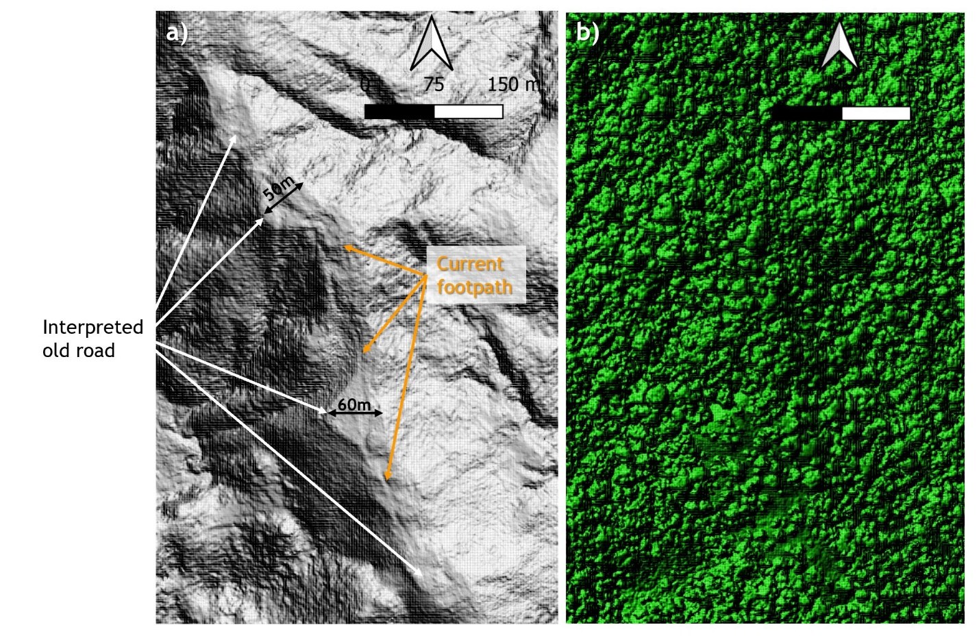
Figure 1. a) LiDAR "Bare Earth" image showing the road-like feature, which is up to 60m wide, and the superimposed footpath that is currently in use by the local people; b) the same area showing the LiDAR image of the jungle canopy in which the road-like structure is imperceptible.
To view an enhanced version of Figure 1, please visit:
https://orders.newsfilecorp.com/files/2477/55567_87962e04a41f89f2_001full.jpg
About LiDAR
LiDAR stands for Light Detection And Ranging, and is a method by which millions of pulses of light are directed downwards from an aircraft, in our case, a helicopter, flying about 500m above the ground. The pulses are reflected back to a detector, and instantaneous measurements of the distance travelled result in an image of the surface. In dense jungle, the vast majority of the reflections are off the vegetation, but some pulses do get through to the floor of the jungle. The classification of the data determines the furthest reflection and assumes that it was reflected off the ground, to provide a "bare earth" image in which it appears that the vegetation has been removed. Our LiDAR survey of priority areas of the Lost Cities - Cutucu Project has provided the first-ever view of the earth's surface beneath the jungle cover, producing a snapshot of geological features, including layers in sedimentary rocks. The images show fault systems spectacularly well - and these are important because they provide the plumbing system that brings metal-bearing fluids from deep in the earth's crust to environments in which ore deposits are likely to form. Most known gold deposits throughout the world are located adjacent to geological faults - hence our focus on these structures in our exploration.
Details of the LiDAR Survey
The survey was undertaken by MPX Geophysics Ltd of Ontario, Canada, with a helicopter and crew contracted from Avioandes, of Quito, Ecuador. The survey was flown at a mean terrain clearance of 500m, with an average line spacing of 250m, using 100% LiDAR swath overlap.
Qualified Persons
The technical information contained in this news release has been verified and approved by Jean-Paul Pallier, MSc. Mr. Pallier is a designated EurGeol by the European Federation of Geologists and is a Qualified Person as defined by National Instrument 43-101, Standards of Disclosure for Mineral Projects of the Canadian Securities Administrators.
The technical information pertaining to geophysical data and related interpretations in this news release has been verified and approved by Jeremy S. Brett, M.Sc., P.Geo., an independent Senior Geophysical Consultant with MPH Consulting Limited. Mr. Brett is a Professional Geoscientist registered in the Province of Ontario and is a Qualified Person as defined by National Instrument 43-101, Standards of Disclosure for Mineral Projects of the Canadian Securities Administrators.
About Aurania
Aurania is a mineral exploration company engaged in the identification, evaluation, acquisition and exploration of mineral property interests, with a focus on precious metals and copper. Its flagship asset, The Lost Cities - Cutucu Project, is located in the Jurassic Metallogenic Belt in the eastern foothills of the Andes mountain range of southeastern Ecuador.
Information on Aurania and technical reports are available at www.aurania.com and www.sedar.com, as well as on Facebook at https://www.facebook.com/auranialtd/, Twitter at https://twitter.com/auranialtd, and LinkedIn at https://www.linkedin.com/company/aurania-resources-ltd-.
For further information, please contact:
Carolyn Muir
VP Investor Relations
Aurania Resources Ltd.
(416) 367-3200
[email protected]
Dr. Richard Spencer
President
Aurania Resources Ltd.
(416) 367-3200
[email protected]
Neither the TSX Venture Exchange nor its Regulation Services Provider (as that term is defined in the policies of the TSX Venture Exchange) accepts responsibility for the adequacy or accuracy of this release.
Forward-Looking Statements
This news release may contain forward-looking information that involves substantial known and unknown risks and uncertainties, most of which are beyond the control of Aurania. Forward-looking statements include estimates and statements that describe Aurania's future plans, objectives or goals, including words to the effect that Aurania or its management expects a stated condition or result to occur. Forward-looking statements may be identified by such terms as "believes", "anticipates", "expects", "estimates", "may", "could", "would", "will", or "plan". Since forward-looking statements are based on assumptions and address future events and conditions, by their very nature they involve inherent risks and uncertainties. Although these statements are based on information currently available to Aurania, Aurania provides no assurance that actual results will meet management's expectations. Risks, uncertainties and other factors involved with forward-looking information could cause actual events, results, performance, prospects and opportunities to differ materially from those expressed or implied by such forward-looking information. Forward looking information in this news release includes, but is not limited to, Aurania's objectives, goals or future plans, statements, exploration results, potential mineralization, the corporation's portfolio, treasury, management team and enhanced capital markets profile, the estimation of mineral resources, exploration and mine development plans, timing of the commencement of operations and estimates of market conditions. Factors that could cause actual results to differ materially from such forward-looking information include, but are not limited to, failure to identify mineral resources, failure to convert estimated mineral resources to reserves, the inability to complete a feasibility study which recommends a production decision, the preliminary nature of metallurgical test results, delays in obtaining or failures to obtain required governmental, regulatory, environmental or other project approvals, political risks, inability to fulfill the duty to accommodate indigenous peoples, uncertainties relating to the availability and costs of financing needed in the future, changes in equity markets, inflation, changes in exchange rates, fluctuations in commodity prices, delays in the development of projects, capital and operating costs varying significantly from estimates and the other risks involved in the mineral exploration and development industry, and those risks set out in Aurania's public documents filed on SEDAR. Although Aurania believes that the assumptions and factors used in preparing the forward-looking information in this news release are reasonable, undue reliance should not be placed on such information, which only applies as of the date of this news release, and no assurance can be given that such events will occur in the disclosed time frames or at all. Aurania disclaims any intention or obligation to update or revise any forward-looking information, whether as a result of new information, future events or otherwise, other than as required by law.
To view the source version of this press release, please visit https://www.newsfilecorp.com/release/55567
Please make the indicated changes including the new text: US quotes snapshot data provided by IEX. Additional price data and company information powered by Twelve Data.